|
|
|
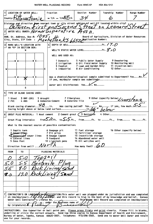
Specific Water Well Detail |
|
|
| Location Info | |||
| Owner: Farmer Cooperative Assoc. | Status: Plugged | ||
| Location: T6S, R11E, Sec. 34, NE SW NE | County: Pottawatomie | ||
| Directions: between 1st St and 2nd St on Leonard St | |||
| Latitude: 39.488775 | Longitude: -96.1707462 | Datum NAD 27 | |
| Latitude: 39.4887708 | Longitude: -96.1710227 | Datum NAD 83 | |
| Longitude and latitude calculated by Survey from township-range-section-quarter calls. Only good to within the quarter call accuracy. | |||
| View well on interactive map | |||
| General Info | ||
| Well Depth: 17 ft. | Elevation: ft. | |
| Static Water Level: 8 ft. | Est. Yield: gpm. | |
| Comp. Date: 15-Oct-2000 | Well Use: (unstated)/abandoned | |
| DWR Applic. #: | Other ID: | |
| Driller Info | ||
| Driller: Briesenthal, Rodney | License #: | |
| Scanned Form | View scan |
| Casing Info | ||
|
Casing Type:
Diam: in. Casing height above land surface: in | ||
| Grout Info | ||
| Grout used: | From: to ft | |
| Source of Possible Contamination | ||
| Source: | ||
| Direction from well: | Distance: ft | |