|
|
|
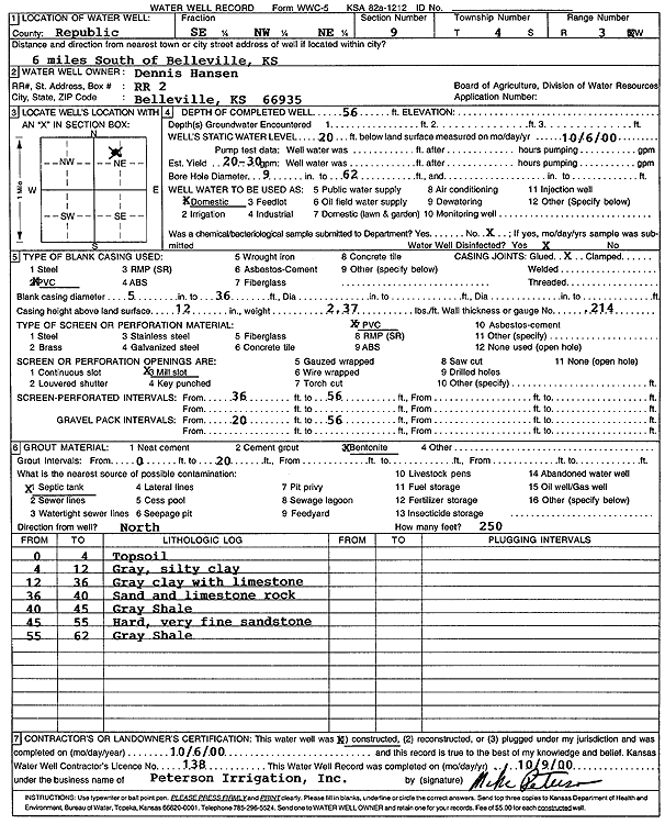
Specific Water Well Detail |
|
|
| Location Info | |||
| Owner: Hansen, Dennis | Status: Constructed | ||
| Location: T4S, R3W, Sec. 9, SE NW NE | County: Republic | ||
| Directions: from Belleville, 6 mi S | |||
| Latitude: 39.7229058 | Longitude: -97.6572626 | Datum NAD 27 | |
| Latitude: 39.7229104 | Longitude: -97.6575817 | Datum NAD 83 | |
| Longitude and latitude calculated by Survey from township-range-section-quarter calls. Only good to within the quarter call accuracy. | |||
| View well on interactive map | |||
| General Info | ||
| Well Depth: 56 ft. | Elevation: ft. | |
| Static Water Level: 20 ft. | Est. Yield: 20 gpm. | |
| Comp. Date: 06-Oct-2000 | Well Use: Domestic | |
| DWR Applic. #: | Other ID: | |
| Driller Info | ||
| Driller: Michael Peterson Irrigation, Inc. | License #: 138 | |
| Scanned Form | View scan |
|
Chemical Sample Submitted?:
Water Well disinfected?: | ||
| Casing Info | ||
| Casing Type:
Casing Joints: |
Diam: in. to ft | |
| Casing height above land surface: in
Casing Weight: lbs/ft Wall thickness or gauge no.: | ||
| Screen and Perforation Info | ||
| Screen Type: | Screen Openings: | |
| Screen-perforated intervals | From: ft to ft | |
| Gravel pack intervals | From: ft to ft | |
| Grout Info | ||
| Grout used: | From: to ft | |
| Source of Possible Contamination | ||
| Source: | ||
| Direction from well: | Distance: ft | |
| Lithologic Log
(Log data entered by KGS.) | ||
| From: 0 ft. to 4 ft. | top soil | |
| From: 4 ft. to 12 ft. | gray, silty clay | |
| From: 12 ft. to 36 ft. | gray clay with limestone | |
| From: 36 ft. to 40 ft. | sand and limestone rock | |
| From: 40 ft. to 45 ft. | gray shale | |
| From: 45 ft. to 55 ft. | hard very fine sandstone | |
| From: 55 ft. to 62 ft. | gray shale | |