|
|
|
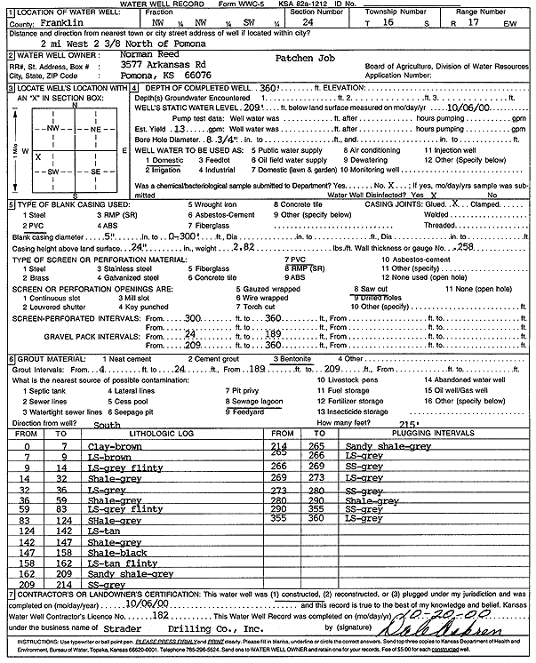
Specific Water Well Detail |
|
|
| Location Info | |||
| Owner: Reed, Norman | Status: Constructed | ||
| Location: T16S, R17E, Sec. 24, NW NW SW | County: Franklin | ||
| Directions: from Pomona: 2 mi W and 2.375 mi N | |||
| Latitude: 38.6439946 | Longitude: -95.4889151 | Datum NAD 27 | |
| Latitude: 38.6440036 | Longitude: -95.4891727 | Datum NAD 83 | |
| Longitude and latitude calculated by Survey from township-range-section-quarter calls. Only good to within the quarter call accuracy. | |||
| View well on interactive map | |||
| General Info | ||
| Well Depth: 360 ft. | Elevation: ft. | |
| Static Water Level: 209 ft. | Est. Yield: 13 gpm. | |
| Comp. Date: 06-Oct-2000 | Well Use: Domestic | |
| DWR Applic. #: | Other ID: | |
| Driller Info | ||
| Driller: Strader Drilling Co., Inc. | License #: 182 | |
| Scanned Form | View scan |
|
Chemical Sample Submitted?:
Water Well disinfected?: | ||
| Casing Info | ||
| Casing Type:
Casing Joints: |
Diam: in. to ft | |
| Casing height above land surface: in
Casing Weight: lbs/ft Wall thickness or gauge no.: | ||
| Screen and Perforation Info | ||
| Screen Type: | Screen Openings: | |
| Screen-perforated intervals | From: ft to ft | |
| Gravel pack intervals | From: ft to ft | |
| Grout Info | ||
| Grout used: | From: to ft | |
| Source of Possible Contamination | ||
| Source: | ||
| Direction from well: | Distance: ft | |
| Lithologic Log
(Log data entered by KGS.) | ||
| From: 0 ft. to 7 ft. | Clay, brown | |
| From: 7 ft. to 9 ft. | Limestone, brown | |
| From: 9 ft. to 14 ft. | Limestone, gray, flinty | |
| From: 14 ft. to 32 ft. | Shale, gray | |
| From: 32 ft. to 36 ft. | Limestone, gray | |
| From: 36 ft. to 59 ft. | Shale, gray | |
| From: 59 ft. to 83 ft. | Limestone, gray, flinty | |
| From: 83 ft. to 124 ft. | Shale, gray | |
| From: 124 ft. to 142 ft. | Limestone, tan | |
| From: 142 ft. to 147 ft. | Shale, gray | |
| From: 147 ft. to 158 ft. | Shale, black | |
| From: 158 ft. to 162 ft. | Limestone, tan, flinty | |
| From: 162 ft. to 209 ft. | Sandy shale, gray | |
| From: 209 ft. to 214 ft. | Sandstone, gray | |
| From: 214 ft. to 265 ft. | Sandy shale, gray | |
| From: 265 ft. to 266 ft. | Limestone, gray | |
| From: 266 ft. to 269 ft. | Sandstone, gray | |
| From: 269 ft. to 273 ft. | Limestone, gray | |
| From: 273 ft. to 280 ft. | Sandstone, gray | |
| From: 280 ft. to 290 ft. | Shale, gray | |
| From: 290 ft. to 355 ft. | Sandstone, gray | |
| From: 355 ft. to 360 ft. | Limestone, gray | |