|
|
|
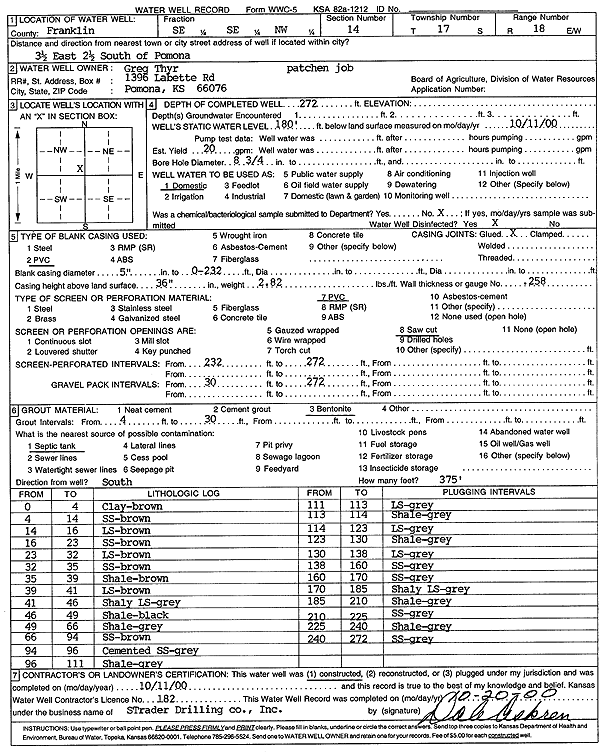
Specific Water Well Detail |
|
|
| Location Info | |||
| Owner: Thyr, Greg | Status: Constructed | ||
| Location: T17S, R18E, Sec. 14, SE SE NW | County: Franklin | ||
| Directions: 3.5 mi E, 2.5 mi S of Pomona | |||
| Latitude: 38.5728174 | Longitude: -95.3886814 | Datum NAD 27 | |
| Latitude: 38.5728292 | Longitude: -95.3889365 | Datum NAD 83 | |
| Longitude and latitude calculated by Survey from township-range-section-quarter calls. Only good to within the quarter call accuracy. | |||
| View well on interactive map | |||
| General Info | ||
| Well Depth: 272 ft. | Elevation: ft. | |
| Static Water Level: 180 ft. | Est. Yield: 20 gpm. | |
| Comp. Date: 11-Oct-2000 | Well Use: Domestic | |
| DWR Applic. #: | Other ID: | |
| Driller Info | ||
| Driller: Strader Drilling Co., Inc. | License #: 182 | |
| Scanned Form | View scan |
|
Chemical Sample Submitted?:
Water Well disinfected?: | ||
| Casing Info | ||
| Casing Type:
Casing Joints: |
Diam: in. to ft | |
| Casing height above land surface: in
Casing Weight: lbs/ft Wall thickness or gauge no.: | ||
| Screen and Perforation Info | ||
| Screen Type: | Screen Openings: | |
| Screen-perforated intervals | From: ft to ft | |
| Gravel pack intervals | From: ft to ft | |
| Grout Info | ||
| Grout used: | From: to ft | |
| Source of Possible Contamination | ||
| Source: | ||
| Direction from well: | Distance: ft | |
| Lithologic Log
(Log data entered by KGS.) | ||
| From: 0 ft. to 4 ft. | Clay, brown | |
| From: 4 ft. to 14 ft. | Sandstone, brown | |
| From: 14 ft. to 16 ft. | Limestone, brown | |
| From: 16 ft. to 23 ft. | Sandstone, brown | |
| From: 23 ft. to 32 ft. | Limestone, brown | |
| From: 32 ft. to 35 ft. | Sandstone, brown | |
| From: 35 ft. to 39 ft. | Shale, brown | |
| From: 39 ft. to 41 ft. | Limestone, brown | |
| From: 41 ft. to 46 ft. | Shaley limestone, gray | |
| From: 46 ft. to 49 ft. | Shale, black | |
| From: 49 ft. to 66 ft. | Shale, gray | |
| From: 66 ft. to 94 ft. | Sandstone, brown | |
| From: 94 ft. to 96 ft. | Cemented sandstone, gray | |
| From: 96 ft. to 111 ft. | Shale, gray | |
| From: 111 ft. to 113 ft. | Limestone, gray | |
| From: 113 ft. to 114 ft. | Shale, gray | |
| From: 114 ft. to 123 ft. | Limestone, gray | |
| From: 123 ft. to 130 ft. | Shale, gray | |
| From: 130 ft. to 138 ft. | Limestone, gray | |
| From: 138 ft. to 160 ft. | Sandstone, gray | |
| From: 160 ft. to 170 ft. | Sandstone, gray | |
| From: 170 ft. to 185 ft. | Shaley limestone, gray | |
| From: 185 ft. to 210 ft. | Shale, gray | |
| From: 210 ft. to 225 ft. | Sandstone, gray | |
| From: 225 ft. to 240 ft. | Shale, gray | |
| From: 240 ft. to 272 ft. | Sandstone, gray | |