|
|
|
Specific Water Well Detail |
|
|
| Location Info | |||
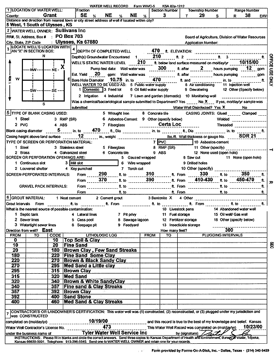
| Owner: Sullivans Inc. | Status: Constructed | ||
| Location: T29S, R38W, Sec. 3, SE NE NE | County: Grant | ||
| Directions: from Ulysses: 5 mi W, 1 mi S | |||
| Latitude: 37.559366 | Longitude: -101.4540899 | Datum NAD 27 | |
| Latitude: 37.5593861 | Longitude: -101.4545366 | Datum NAD 83 | |
| Longitude and latitude calculated by Survey from township-range-section-quarter calls. Only good to within the quarter call accuracy. | |||
| View well on interactive map | |||
| General Info | ||
| Well Depth: 470 ft. | Elevation: ft. | |
| Static Water Level: 210 ft. | Est. Yield: 20 gpm. | |
| Comp. Date: 19-Oct-2000 | Well Use: Domestic | |
| DWR Applic. #: | Other ID: | |
| Driller Info | ||
| Driller: Destal Tyler Water Well Service | License #: 473 | |
| Scanned Form | View scan |
|
Chemical Sample Submitted?:
Water Well disinfected?: | ||
| Casing Info | ||
| Casing Type:
Casing Joints: |
Diam: in. to ft | |
| Casing height above land surface: in
Casing Weight: lbs/ft Wall thickness or gauge no.: | ||
| Screen and Perforation Info | ||
| Screen Type: | Screen Openings: | |
| Screen-perforated intervals | From: ft to ft | |
| Gravel pack intervals | From: ft to ft | |
| Grout Info | ||
| Grout used: | From: to ft | |
| Source of Possible Contamination | ||
| Source: | ||
| Direction from well: | Distance: ft | |
| Lithologic Log
(Log data entered by KGS.) | ||
| From: 0 ft. to 10 ft. | Top Soil and Clay | |
| From: 10 ft. to 20 ft. | Fine Sand | |
| From: 20 ft. to 180 ft. | Brown Clay, Few Sandy Streaks | |
| From: 180 ft. to 220 ft. | Fine Sand Some Clay | |
| From: 220 ft. to 270 ft. | Brown and Black Sandy Clay | |
| From: 270 ft. to 295 ft. | Med Sand a Little clay | |
| From: 295 ft. to 315 ft. | Brown Clay | |
| From: 315 ft. to 320 ft. | Med Sand | |
| From: 320 ft. to 340 ft. | Brown and White Sandy Clay | |
| From: 340 ft. to 357 ft. | Fine Sand and Clay Streaks | |
| From: 357 ft. to 392 ft. | Brown Clay | |
| From: 392 ft. to 400 ft. | Sand Stone | |
| From: 400 ft. to 460 ft. | Med Sand and Clay Streaks | |