|
|
|
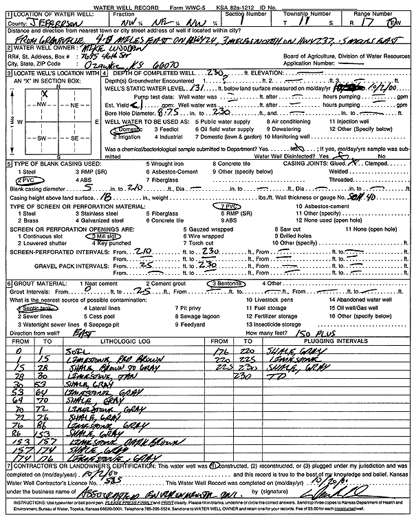
Specific Water Well Detail |
|
|
| Location Info | |||
| Owner: Wooden, Mike | Status: Constructed | ||
| Location: T11S, R17E, Sec. 1, NW NE NW | County: Jefferson | ||
| Directions: from Grantville: 4 mi E on Hwy 24, 3 mi N on Hwy 237, 5 mi E | |||
| Latitude: 39.1282939 | Longitude: -95.4774511 | Datum NAD 27 | |
| Latitude: 39.1282933 | Longitude: -95.4777044 | Datum NAD 83 | |
| Longitude and latitude calculated by Survey from township-range-section-quarter calls. Only good to within the quarter call accuracy. | |||
| View well on interactive map | |||
| General Info | ||
| Well Depth: 230 ft. | Elevation: ft. | |
| Static Water Level: 131 ft. | Est. Yield: 1 gpm. | |
| Comp. Date: 02-Oct-2000 | Well Use: Domestic | |
| DWR Applic. #: | Other ID: | |
| Driller Info | ||
| Driller: Associated Environmental, Inc. | License #: 585 | |
| Scanned Form | View scan |
|
Chemical Sample Submitted?:
Water Well disinfected?: | ||
| Casing Info | ||
| Casing Type:
Casing Joints: |
Diam: in. to ft | |
| Casing height above land surface: in
Casing Weight: lbs/ft Wall thickness or gauge no.: | ||
| Screen and Perforation Info | ||
| Screen Type: | Screen Openings: | |
| Screen-perforated intervals | From: ft to ft | |
| Gravel pack intervals | From: ft to ft | |
| Grout Info | ||
| Grout used: | From: to ft | |
| Source of Possible Contamination | ||
| Source: | ||
| Direction from well: | Distance: ft | |
| Lithologic Log
(Log data entered by KGS.) | ||
| From: 0 ft. to 1 ft. | soil | |
| From: 1 ft. to 15 ft. | limestone, red brown | |
| From: 15 ft. to 28 ft. | shale, brown to gray | |
| From: 28 ft. to 30 ft. | limestone, tan | |
| From: 30 ft. to 53 ft. | shale, gray | |
| From: 53 ft. to 64 ft. | limestone, gray | |
| From: 64 ft. to 70 ft. | shale, gray | |
| From: 70 ft. to 72 ft. | limestone, gray | |
| From: 72 ft. to 76 ft. | shale, gray | |
| From: 76 ft. to 86 ft. | limestone, gray | |
| From: 86 ft. to 153 ft. | shale, gray | |
| From: 153 ft. to 157 ft. | limestone, dark brown | |
| From: 157 ft. to 174 ft. | shale, gray | |
| From: 174 ft. to 176 ft. | limestone, gray | |
| From: 176 ft. to 220 ft. | shale, gray | |
| From: 220 ft. to 225 ft. | limestone | |
| From: 225 ft. to 230 ft. | shale, gray | |