|
|
|
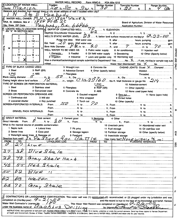
Specific Water Well Detail |
|
|
| Location Info | |||
| Owner: M.H. Wilson Ranch | Status: Constructed | ||
| Location: T20S, R4E, Sec. 30, SE SE SW | County: Marion | ||
| Directions: from Peabody: 1 mi N, 3.5 mi E | |||
| Latitude: 38.2765406 | Longitude: -97.0317721 | Datum NAD 27 | |
| Latitude: 38.2765573 | Longitude: -97.0320756 | Datum NAD 83 | |
| Longitude and latitude calculated by Survey from township-range-section-quarter calls. Only good to within the quarter call accuracy. | |||
| View well on interactive map | |||
| General Info | ||
| Well Depth: 70 ft. | Elevation: ft. | |
| Static Water Level: 23 ft. | Est. Yield: 20 gpm. | |
| Comp. Date: 21-Sep-2000 | Well Use: Domestic | |
| DWR Applic. #: | Other ID: | |
| Driller Info | ||
| Driller: Paul H. Backhus Drilling | License #: 180 | |
| Scanned Form | View scan |
|
Chemical Sample Submitted?:
Water Well disinfected?: | ||
| Casing Info | ||
| Casing Type:
Casing Joints: |
Diam: in. to ft | |
| Casing height above land surface: in
Casing Weight: lbs/ft Wall thickness or gauge no.: | ||
| Screen and Perforation Info | ||
| Screen Type: | Screen Openings: | |
| Screen-perforated intervals | From: ft to ft | |
| Gravel pack intervals | From: ft to ft | |
| Grout Info | ||
| Grout used: | From: to ft | |
| Source of Possible Contamination | ||
| Source: | ||
| Direction from well: | Distance: ft | |
| Lithologic Log
(Log data entered by KGS.) | ||
| From: 0 ft. to 27 ft. | limestone | |
| From: 27 ft. to 38 ft. | blue shale | |
| From: 38 ft. to 42 ft. | gray shale, hard | |
| From: 42 ft. to 55 ft. | red shale | |
| From: 55 ft. to 62 ft. | blue shale | |
| From: 62 ft. to 63 ft. | water | |
| From: 63 ft. to 70 ft. | gray shale | |