|
|
|
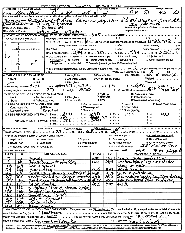
Specific Water Well Detail |
|
|
| Location Info | |||
| Owner: Triple T Farms | Status: Constructed | ||
| Location: T24S, R42W, Sec. 2, C NE SE | County: Hamilton | ||
| Directions: 8.5 mi W on River Rd, 200' S, S end of River Bridge on Hwy 270, Syracuse | |||
| Latitude: 37.9919278 | Longitude: -101.8918226 | Datum NAD 27 | |
| Latitude: 37.9919407 | Longitude: -101.8922777 | Datum NAD 83 | |
| Longitude and latitude calculated by Survey from township-range-section-quarter calls. Only good to within the quarter call accuracy. | |||
| View well on interactive map | |||
| General Info | ||
| Well Depth: 300 ft. | Elevation: ft. | |
| Static Water Level: 15 ft. | Est. Yield: gpm. | |
| Comp. Date: 07-Nov-2000 | Well Use: Domestic | |
| DWR Applic. #: | Other ID: | |
| Driller Info | ||
| Driller: Ray Cramer Drilling Co. | License #: 600 | |
| Scanned Form | View scan |
|
Chemical Sample Submitted?:
Water Well disinfected?: | ||
| Casing Info | ||
| Casing Type:
Casing Joints: |
Diam: in. to ft | |
| Casing height above land surface: in
Casing Weight: lbs/ft Wall thickness or gauge no.: | ||
| Screen and Perforation Info | ||
| Screen Type: | Screen Openings: | |
| Screen-perforated intervals | From: ft to ft | |
| Gravel pack intervals | From: ft to ft | |
| Grout Info | ||
| Grout used: | From: to ft | |
| Source of Possible Contamination | ||
| Source: | ||
| Direction from well: | Distance: ft | |
| Lithologic Log
(Log data entered by KGS.) | ||
| From: 0 ft. to 3 ft. | topsoil | |
| From: 3 ft. to 13 ft. | tan and brown sandy clay | |
| From: 13 ft. to 24 ft. | large gravel | |
| From: 24 ft. to 36 ft. | black clay | |
| From: 36 ft. to 68 ft. | black clay streaks in black shale | |
| From: 68 ft. to 88 ft. | shale with small sandstone streaks | |
| From: 88 ft. to 112 ft. | sandstone with cemented fine sand | |
| From: 112 ft. to 119 ft. | black shale | |
| From: 119 ft. to 138 ft. | sandstone with sand streaks (soft) | |
| From: 138 ft. to 166 ft. | sandstone (hard) | |
| From: 166 ft. to 168 ft. | sandstone (soft) | |
| From: 168 ft. to 179 ft. | shale (hard) | |
| From: 179 ft. to 202 ft. | shale (soft) | |
| From: 202 ft. to 215 ft. | black shale | |
| From: 215 ft. to 234 ft. | gray and white sandy clay | |
| From: 234 ft. to 265 ft. | soft sandstone with shale and sandy clay streaks | |
| From: 265 ft. to 269 ft. | hard shale | |
| From: 269 ft. to 273 ft. | soft sandstone | |
| From: 273 ft. to 278 ft. | gray and white sandy clay with sandstone | |
| From: 278 ft. to 295 ft. | soft sandstone with gray sandy clay | |
| From: 295 ft. to 300 ft. | hard | |