|
|
|
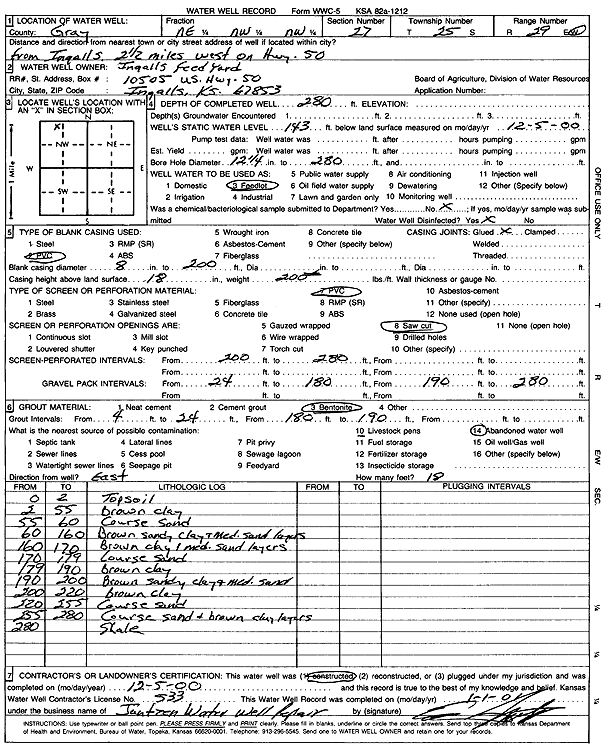
Specific Water Well Detail |
|
|
| Location Info | |||
| Owner: Ingalls Feed Yard | Status: Constructed | ||
| Location: T25S, R29W, Sec. 27, NE NW NW | County: Gray | ||
| Directions: from Ingalls: 2.5 mi W on Hwy 50 | |||
| Latitude: 37.8558191 | Longitude: -100.4977059 | Datum NAD 27 | |
| Latitude: 37.8558408 | Longitude: -100.4981332 | Datum NAD 83 | |
| Longitude and latitude calculated by Survey from township-range-section-quarter calls. Only good to within the quarter call accuracy. | |||
| View well on interactive map | |||
| General Info | ||
| Well Depth: 280 ft. | Elevation: ft. | |
| Static Water Level: 143 ft. | Est. Yield: gpm. | |
| Comp. Date: 05-Dec-2000 | Well Use: Feedlot | |
| DWR Applic. #: | Other ID: | |
| Links | |
| No Wizard information available. | |
| View info from WIMAS Water Right Data base... | |
| Driller Info | ||
| Driller: Ed Jantzen Water Well Repair | License #: 533 | |
| Scanned Form | View scan |
|
Chemical Sample Submitted?:
Water Well disinfected?: | ||
| Casing Info | ||
| Casing Type:
Casing Joints: |
Diam: in. to ft | |
| Casing height above land surface: in
Casing Weight: lbs/ft Wall thickness or gauge no.: | ||
| Screen and Perforation Info | ||
| Screen Type: | Screen Openings: | |
| Screen-perforated intervals | From: ft to ft | |
| Gravel pack intervals | From: ft to ft | |
| Grout Info | ||
| Grout used: | From: to ft | |
| Source of Possible Contamination | ||
| Source: | ||
| Direction from well: | Distance: ft | |
| Lithologic Log
(Log data entered by KGS.) | ||
| From: 0 ft. to 2 ft. | Topsoil | |
| From: 2 ft. to 55 ft. | Brown clay | |
| From: 55 ft. to 60 ft. | Coarse Sand | |
| From: 60 ft. to 160 ft. | Brown sandy clay and medium sand layers | |
| From: 160 ft. to 170 ft. | Brown clay and medium sand layers | |
| From: 170 ft. to 179 ft. | Coarse sand | |
| From: 179 ft. to 190 ft. | Brown clay | |
| From: 190 ft. to 200 ft. | Brown sandy clay and medium sand | |
| From: 200 ft. to 220 ft. | Brown clay | |
| From: 220 ft. to 255 ft. | Coarse sand | |
| From: 255 ft. to 280 ft. | Coarse sand and brown clay layers | |
| From: 280 ft. to ft. | Shale | |