|
|
|
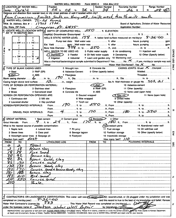
Specific Water Well Detail |
|
|
| Location Info | |||
| Owner: Tri-Ad Farms | Status: Constructed | ||
| Location: T26S, R28W, Sec. 34, NE NE SE | County: Gray | ||
| Directions: from Cimarron, 3 mi S on Hwy 23, 1 mi W, .5 mi S | |||
| Latitude: 37.7436336 | Longitude: -100.3613502 | Datum NAD 27 | |
| Latitude: 37.7436557 | Longitude: -100.3617738 | Datum NAD 83 | |
| Longitude and latitude calculated by Survey from township-range-section-quarter calls. Only good to within the quarter call accuracy. | |||
| View well on interactive map | |||
| General Info | ||
| Well Depth: 250 ft. | Elevation: ft. | |
| Static Water Level: 158 ft. | Est. Yield: gpm. | |
| Comp. Date: 26-Sep-2000 | Well Use: Domestic | |
| DWR Applic. #: | Other ID: | |
| Driller Info | ||
| Driller: Ed Jantzen Water Well Repair | License #: 533 | |
| Scanned Form | View scan |
|
Chemical Sample Submitted?:
Water Well disinfected?: | ||
| Casing Info | ||
| Casing Type:
Casing Joints: |
Diam: in. to ft | |
| Casing height above land surface: in
Casing Weight: lbs/ft Wall thickness or gauge no.: | ||
| Screen and Perforation Info | ||
| Screen Type: | Screen Openings: | |
| Screen-perforated intervals | From: ft to ft | |
| Gravel pack intervals | From: ft to ft | |
| Grout Info | ||
| Grout used: | From: to ft | |
| Source of Possible Contamination | ||
| Source: | ||
| Direction from well: | Distance: ft | |
| Lithologic Log
(Log data entered by KGS.) | ||
| From: 0 ft. to 2 ft. | Topsoil | |
| From: 2 ft. to 18 ft. | Brown clay | |
| From: 18 ft. to 38 ft. | Fine Sand | |
| From: 38 ft. to 42 ft. | Brown clay | |
| From: 42 ft. to 82 ft. | Brown sandy clay | |
| From: 82 ft. to 130 ft. | Coarse sand | |
| From: 130 ft. to 132 ft. | Brown sandy clay | |
| From: 132 ft. to 170 ft. | coarse sand and brown sandy clay | |
| From: 170 ft. to 183 ft. | brown clay | |
| From: 183 ft. to 210 ft. | Medium sand | |
| From: 210 ft. to 250 ft. | Coarse sand | |
| From: 250 ft. to ft. | Shale | |