|
|
|
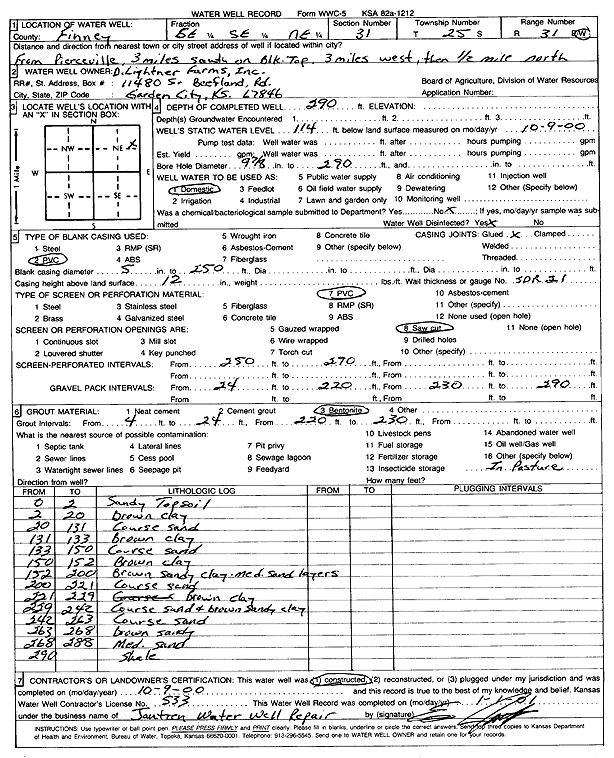
Specific Water Well Detail |
|
|
| Location Info | |||
| Owner: D. Lightner Farms, Inc. | Status: Constructed | ||
| Location: T25S, R31W, Sec. 31, SE SE NE | County: Finney | ||
| Directions: from Pierceville, 3 mi S on Blk top, 3 mi W, .5 mi N | |||
| Latitude: 37.8372901 | Longitude: -100.7566347 | Datum NAD 27 | |
| Latitude: 37.8373133 | Longitude: -100.7570711 | Datum NAD 83 | |
| Longitude and latitude calculated by Survey from township-range-section-quarter calls. Only good to within the quarter call accuracy. | |||
| View well on interactive map | |||
| General Info | ||
| Well Depth: 290 ft. | Elevation: ft. | |
| Static Water Level: 114 ft. | Est. Yield: gpm. | |
| Comp. Date: 09-Oct-2000 | Well Use: Domestic | |
| DWR Applic. #: | Other ID: | |
| Driller Info | ||
| Driller: Ed Jantzen Water Well Repair | License #: 533 | |
| Scanned Form | View scan |
|
Chemical Sample Submitted?:
Water Well disinfected?: | ||
| Casing Info | ||
| Casing Type:
Casing Joints: |
Diam: in. to ft | |
| Casing height above land surface: in
Casing Weight: lbs/ft Wall thickness or gauge no.: | ||
| Screen and Perforation Info | ||
| Screen Type: | Screen Openings: | |
| Screen-perforated intervals | From: ft to ft | |
| Gravel pack intervals | From: ft to ft | |
| Grout Info | ||
| Grout used: | From: to ft | |
| Source of Possible Contamination | ||
| Source: | ||
| Direction from well: | Distance: ft | |
| Lithologic Log
(Log data entered by KGS.) | ||
| From: 0 ft. to 2 ft. | sandy topsoil | |
| From: 2 ft. to 20 ft. | brown clay | |
| From: 20 ft. to 131 ft. | coarse sand | |
| From: 131 ft. to 133 ft. | brown clay | |
| From: 133 ft. to 150 ft. | coarse sand | |
| From: 150 ft. to 152 ft. | brown clay | |
| From: 152 ft. to 200 ft. | brown sandy clay medium sand layers | |
| From: 200 ft. to 221 ft. | coarse sand | |
| From: 221 ft. to 229 ft. | brown clay | |
| From: 229 ft. to 242 ft. | coarse sand and brown sandy clay | |
| From: 242 ft. to 263 ft. | coarse sand | |
| From: 263 ft. to 268 ft. | brown sandy | |
| From: 268 ft. to 288 ft. | medium sand | |
| From: 288 ft. to ft. | shale | |