|
|
|
Specific Water Well Detail |
|
|
| Location Info | |||
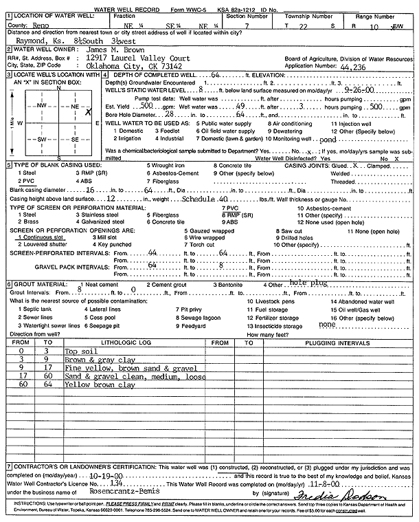
| Owner: Brown, James M. | Status: Constructed | ||
| Location: T22S, R10W, Sec. 7, NE SE NE | County: Reno | ||
| Directions: from Raymond: 8.25 mi S, 3.25 mi W | |||
| Latitude: 38.1537372 | Longitude: -98.4556234 | Datum NAD 27 | |
| Latitude: 38.1537501 | Longitude: -98.4559749 | Datum NAD 83 | |
| Longitude and latitude calculated by Survey from township-range-section-quarter calls. Only good to within the quarter call accuracy. | |||
| View well on interactive map | |||
| General Info | ||
| Well Depth: 64 ft. | Elevation: ft. | |
| Static Water Level: 8 ft. | Est. Yield: gpm. | |
| Comp. Date: 19-Oct-2000 | Well Use: Pond/Swimming Pool/Recreation | |
| DWR Applic. #: 44236 | Other ID: | |
| Links | |
| No Wizard information available. | |
| View info from WIMAS Water Right Data base... | |
| Driller Info | ||
| Driller: Rosencrantz-Bemis Enterprises, Inc. | License #: 134 | |
| Scanned Form | View scan |
|
Chemical Sample Submitted?:
Water Well disinfected?: | ||
| Casing Info | ||
| Casing Type:
Casing Joints: |
Diam: in. to ft | |
| Casing height above land surface: in
Casing Weight: lbs/ft Wall thickness or gauge no.: | ||
| Screen and Perforation Info | ||
| Screen Type: | Screen Openings: | |
| Screen-perforated intervals | From: ft to ft | |
| Gravel pack intervals | From: ft to ft | |
| Grout Info | ||
| Grout used: | From: to ft | |
| Source of Possible Contamination | ||
| Source: | ||
| Direction from well: | Distance: ft | |
| Lithologic Log
(Log data entered by KGS.) | ||
| From: 0 ft. to 3 ft. | top soil | |
| From: 3 ft. to 9 ft. | brown and gray clay | |
| From: 9 ft. to 17 ft. | fine yellow brown sand and gravel | |
| From: 17 ft. to 60 ft. | sand and gravel; clean, medium, loose | |
| From: 60 ft. to 64 ft. | yellow brown clay | |