|
|
|
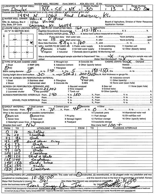
Specific Water Well Detail |
|
|
| Location Info | |||
| Owner: O'Brien, Patrick | Status: Constructed | ||
| Location: T13S, R20E, Sec. 30, NE SE NE | County: Douglas | ||
| Directions: 1484 N 1062 Rd, Lawrence | |||
| Latitude: 38.8945306 | Longitude: -95.2247397 | Datum NAD 27 | |
| Latitude: 38.8945347 | Longitude: -95.2249897 | Datum NAD 83 | |
| Longitude and latitude calculated by Survey from township-range-section-quarter calls. Only good to within the quarter call accuracy. | |||
| View well on interactive map | |||
| General Info | ||
| Well Depth: 160 ft. | Elevation: ft. | |
| Static Water Level: 90 ft. | Est. Yield: 15 gpm. | |
| Comp. Date: 30-Oct-2000 | Well Use: Domestic | |
| DWR Applic. #: | Other ID: | |
| Driller Info | ||
| Driller: Evans Energy Development, Inc. | License #: 561 | |
| Scanned Form | View scan |
|
Chemical Sample Submitted?:
Water Well disinfected?: | ||
| Casing Info | ||
| Casing Type:
Casing Joints: |
Diam: in. to ft | |
| Casing height above land surface: in
Casing Weight: lbs/ft Wall thickness or gauge no.: | ||
| Screen and Perforation Info | ||
| Screen Type: | Screen Openings: | |
| Screen-perforated intervals | From: ft to ft | |
| Gravel pack intervals | From: ft to ft | |
| Grout Info | ||
| Grout used: | From: to ft | |
| Source of Possible Contamination | ||
| Source: | ||
| Direction from well: | Distance: ft | |
| Lithologic Log
(Log data entered by KGS.) | ||
| From: 0 ft. to 16 ft. | soil and clay | |
| From: 16 ft. to 22 ft. | limestone | |
| From: 22 ft. to 42 ft. | shale | |
| From: 42 ft. to 58 ft. | sandstone, gray | |
| From: 58 ft. to 72 ft. | shale | |
| From: 72 ft. to 77 ft. | limestone | |
| From: 77 ft. to 103 ft. | shale | |
| From: 103 ft. to 105 ft. | limestone | |
| From: 105 ft. to 125 ft. | sand and shale | |
| From: 125 ft. to 148 ft. | sandstone | |
| From: 148 ft. to 152 ft. | sandy limestone | |
| From: 152 ft. to 155 ft. | shale | |
| From: 155 ft. to 160 ft. | limestone | |