|
|
|
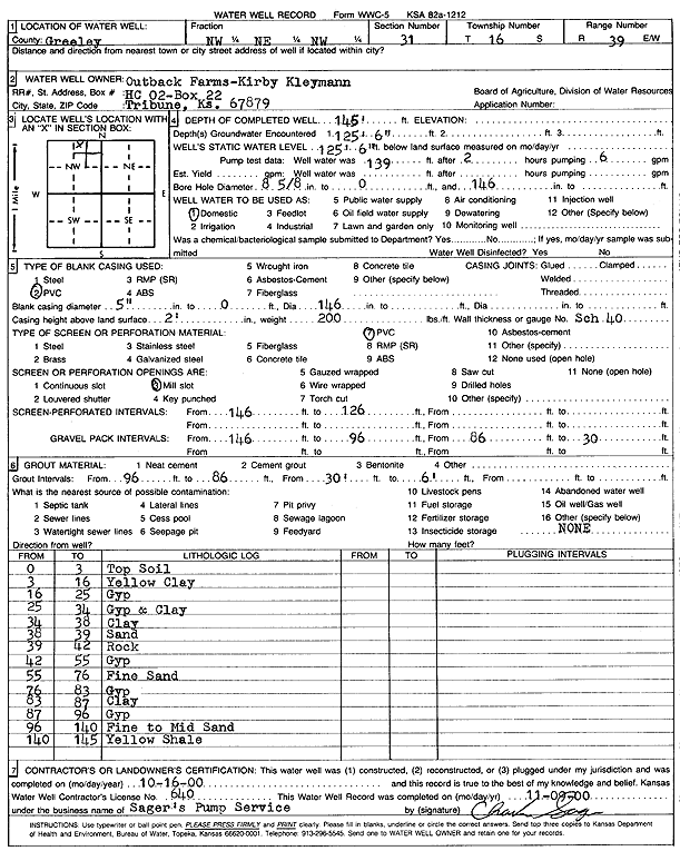
Specific Water Well Detail |
|
|
| Location Info | |||
| Owner: Outback Farms | Status: Constructed | ||
| Location: T16S, R39W, Sec. 31, NW NE NW | County: Greeley | ||
| Directions: | |||
| Latitude: 38.6246787 | Longitude: -101.6720331 | Datum NAD 27 | |
| Latitude: 38.6246928 | Longitude: -101.6724805 | Datum NAD 83 | |
| Longitude and latitude calculated by Survey from township-range-section-quarter calls. Only good to within the quarter call accuracy. | |||
| View well on interactive map | |||
| General Info | ||
| Well Depth: 145 ft. | Elevation: ft. | |
| Static Water Level: 125 ft. | Est. Yield: gpm. | |
| Comp. Date: 16-Oct-2000 | Well Use: Domestic | |
| DWR Applic. #: | Other ID: | |
| Driller Info | ||
| Driller: Sager's Pump Service | License #: 640 | |
| Scanned Form | View scan |
|
Chemical Sample Submitted?:
Water Well disinfected?: | ||
| Casing Info | ||
| Casing Type:
Casing Joints: |
Diam: in. to ft | |
| Casing height above land surface: in
Casing Weight: lbs/ft Wall thickness or gauge no.: | ||
| Screen and Perforation Info | ||
| Screen Type: | Screen Openings: | |
| Screen-perforated intervals | From: ft to ft | |
| Gravel pack intervals | From: ft to ft | |
| Grout Info | ||
| Grout used: | From: to ft | |
| Source of Possible Contamination | ||
| Source: | ||
| Direction from well: | Distance: ft | |
| Lithologic Log
(Log data entered by KGS.) | ||
| From: 0 ft. to 3 ft. | Top soil | |
| From: 3 ft. to 16 ft. | Yellow clay | |
| From: 16 ft. to 25 ft. | Gypsum | |
| From: 25 ft. to 34 ft. | Gypsum and clay | |
| From: 34 ft. to 38 ft. | Clay | |
| From: 38 ft. to 39 ft. | Sand | |
| From: 39 ft. to 42 ft. | Rock | |
| From: 42 ft. to 55 ft. | Gypsum | |
| From: 55 ft. to 76 ft. | Fine sand | |
| From: 76 ft. to 83 ft. | Gypsum | |
| From: 83 ft. to 87 ft. | Clay | |
| From: 87 ft. to 96 ft. | Gypsum | |
| From: 96 ft. to 140 ft. | Fine to medium sand | |
| From: 140 ft. to 145 ft. | Yellow shale | |