|
|
|
Specific Water Well Detail |
|
|
| Location Info | |||
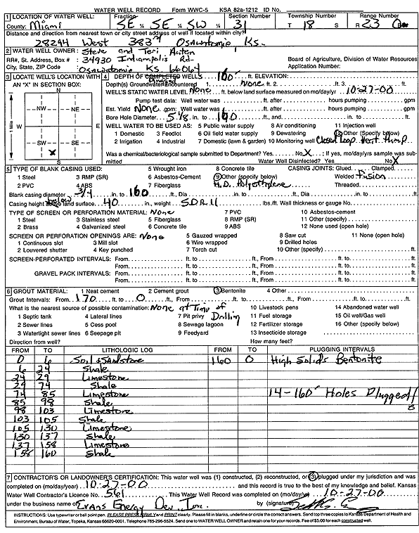
| Owner: Auten, Steve and Teri | Status: Constructed | ||
| Location: T18S, R23E, Sec. 31, SE SE SW | County: Miami | ||
| Directions: 28244 W 383rd, Osawatomie (fourteen 160-foot bores) | |||
| Latitude: 38.4335329 | Longitude: -94.9100672 | Datum NAD 27 | |
| Latitude: 38.4335505 | Longitude: -94.9103091 | Datum NAD 83 | |
| Longitude and latitude calculated by Survey from township-range-section-quarter calls. Only good to within the quarter call accuracy. | |||
| View well on interactive map | |||
| General Info | ||
| Well Depth: 160 ft. | Elevation: ft. | |
| Static Water Level: ft. | Est. Yield: gpm. | |
| Comp. Date: 27-Oct-2000 | Well Use: Heat Pump (Closed Loop/Disposal), Geothermal | |
| DWR Applic. #: | Other ID: | |
| Driller Info | ||
| Driller: Evans Energy Development, Inc. | License #: 561 | |
| Scanned Form | View scan |
|
Chemical Sample Submitted?:
Water Well disinfected?: | ||
| Casing Info | ||
| Casing Type:
Casing Joints: |
Diam: in. to ft | |
| Casing height above land surface: in
Casing Weight: lbs/ft Wall thickness or gauge no.: | ||
| Screen and Perforation Info | ||
| Screen Type: | Screen Openings: | |
| Screen-perforated intervals | From: ft to ft | |
| Gravel pack intervals | From: ft to ft | |
| Grout Info | ||
| Grout used: | From: to ft | |
| Source of Possible Contamination | ||
| Source: | ||
| Direction from well: | Distance: ft | |
| Lithologic Log
(Log data entered by KGS.) | ||
| From: 0 ft. to 6 ft. | soil and sandstone | |
| From: 6 ft. to 24 ft. | shale | |
| From: 24 ft. to 29 ft. | limestone | |
| From: 29 ft. to 74 ft. | shale | |
| From: 74 ft. to 85 ft. | limestone | |
| From: 85 ft. to 98 ft. | shale | |
| From: 98 ft. to 103 ft. | limestone | |
| From: 103 ft. to 105 ft. | shale | |
| From: 105 ft. to 130 ft. | limestone | |
| From: 130 ft. to 137 ft. | shale | |
| From: 137 ft. to 158 ft. | limestone | |
| From: 158 ft. to 160 ft. | shale | |