|
|
|
Specific Water Well Detail |
|
|
| Location Info | |||
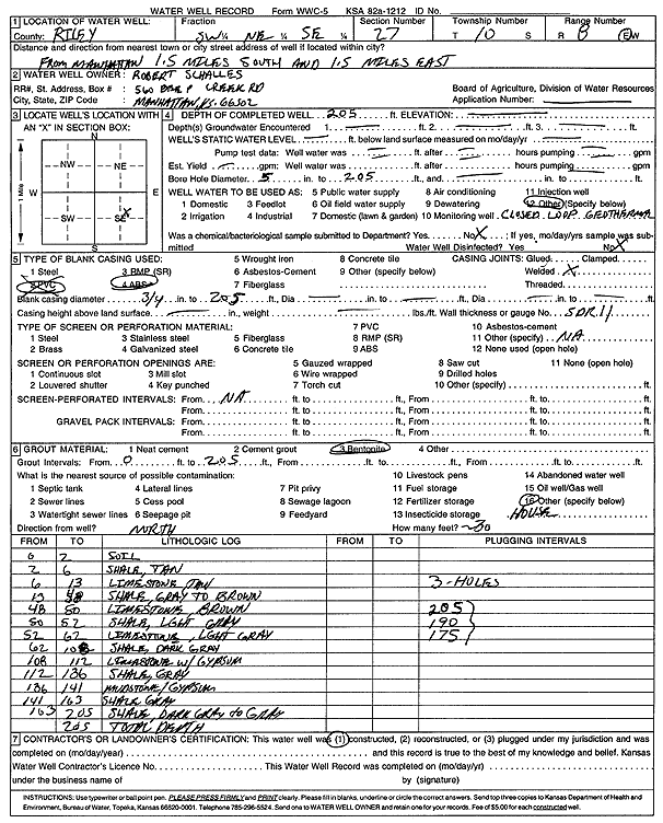
| Owner: Schalles, Robert | Status: Constructed | ||
| Location: T10S, R8E, Sec. 27, SW NE SE | County: Riley | ||
| Directions: from Manhattan: 1.5 mi S, 1.5 mi E (1 bore at 205 feet, 1 bore at 190 feet, 1 bore at 175 feet) | |||
| Latitude: 39.149531 | Longitude: -96.5042974 | Datum NAD 27 | |
| Latitude: 39.1495287 | Longitude: -96.504576 | Datum NAD 83 | |
| Longitude and latitude calculated by Survey from township-range-section-quarter calls. Only good to within the quarter call accuracy. | |||
| View well on interactive map | |||
| General Info | ||
| Well Depth: 205 ft. | Elevation: ft. | |
| Static Water Level: ft. | Est. Yield: gpm. | |
| Comp. Date: | Well Use: Geothermal, Closed Loop, Vertical | |
| DWR Applic. #: | Other ID: | |
| Driller Info | ||
| Driller: Associated Drilling, Inc. | License #: 760 | |
| Scanned Form | View scan |
|
Chemical Sample Submitted?:
Water Well disinfected?: | ||
| Casing Info | ||
| Casing Type:
Casing Joints: |
Diam: in. to ft | |
| Casing height above land surface: in
Casing Weight: lbs/ft Wall thickness or gauge no.: | ||
| Screen and Perforation Info | ||
| Screen Type: | Screen Openings: | |
| Screen-perforated intervals | From: ft to ft | |
| Gravel pack intervals | From: ft to ft | |
| Grout Info | ||
| Grout used: | From: to ft | |
| Source of Possible Contamination | ||
| Source: | ||
| Direction from well: | Distance: ft | |
| Lithologic Log
(Log data entered by KGS.) | ||
| From: 0 ft. to 2 ft. | soil | |
| From: 2 ft. to 6 ft. | shale, tan | |
| From: 6 ft. to 13 ft. | limestone, tan | |
| From: 13 ft. to 48 ft. | shale, gray to brown | |
| From: 48 ft. to 50 ft. | limestone, brown | |
| From: 50 ft. to 52 ft. | shale, light gray | |
| From: 52 ft. to 62 ft. | limestone, light gray | |
| From: 62 ft. to 108 ft. | shale, dark gray | |
| From: 108 ft. to 112 ft. | limestone with gypsum | |
| From: 112 ft. to 136 ft. | shale, gray | |
| From: 136 ft. to 141 ft. | mudstone and gypsum | |
| From: 141 ft. to 163 ft. | shale, gray | |
| From: 163 ft. to 205 ft. | shale, dark gray to gray | |