|
|
|
Specific Water Well Detail |
|
|
| Location Info | |||
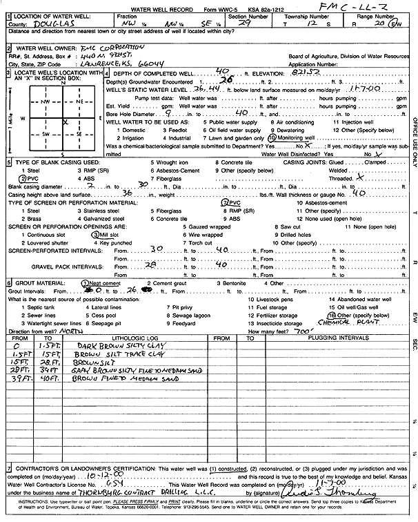
| Owner: FMC Corporation | Status: Constructed | ||
| Location: T12S, R20E, Sec. 29, NW NW SE | County: Douglas | ||
| Directions: | |||
| Latitude: 38.9779161 | Longitude: -95.2130027 | Datum NAD 27 | |
| Latitude: 38.9779183 | Longitude: -95.2132523 | Datum NAD 83 | |
| Longitude and latitude calculated by Survey from township-range-section-quarter calls. Only good to within the quarter call accuracy. | |||
| View well on interactive map | |||
| General Info | ||
| Well Depth: 40 ft. | Elevation: 821.52 ft. | |
| Static Water Level: 26.44 ft. | Est. Yield: gpm. | |
| Comp. Date: 12-Oct-2000 | Well Use: Monitoring well/observation/piezometer | |
| DWR Applic. #: | Other ID: FMC LL 2 | |
| Driller Info | ||
| Driller: Audie L. Thornburg Contract Dewatering, Inc. | License #: 654 | |
| Scanned Form | View scan |
|
Chemical Sample Submitted?:
Water Well disinfected?: | ||
| Casing Info | ||
| Casing Type:
Casing Joints: |
Diam: in. to ft | |
| Casing height above land surface: in
Casing Weight: lbs/ft Wall thickness or gauge no.: | ||
| Screen and Perforation Info | ||
| Screen Type: | Screen Openings: | |
| Screen-perforated intervals | From: ft to ft | |
| Gravel pack intervals | From: ft to ft | |
| Grout Info | ||
| Grout used: | From: to ft | |
| Source of Possible Contamination | ||
| Source: | ||
| Direction from well: | Distance: ft | |
| Lithologic Log
(Log data entered by KGS.) | ||
| From: 0 ft. to 1.5 ft. | dark brown silty clay | |
| From: 1.5 ft. to 15 ft. | brown silt with trace clay | |
| From: 15 ft. to 28 ft. | brown silt | |
| From: 28 ft. to 39 ft. | gray brown silty fine to medium sand | |
| From: 39 ft. to 40 ft. | brown fine to medium sand | |