|
|
|
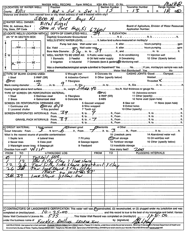
Specific Water Well Detail |
|
|
| Location Info | |||
| Owner: Engel, Errol | Status: Constructed | ||
| Location: T13S, R18W, Sec. 15, NW SW SW | County: Ellis | ||
| Directions: 5800 N Vine St, Hays | |||
| Latitude: 38.9172449 | Longitude: -99.3157728 | Datum NAD 27 | |
| Latitude: 38.9172563 | Longitude: -99.3161538 | Datum NAD 83 | |
| Longitude and latitude calculated by Survey from township-range-section-quarter calls. Only good to within the quarter call accuracy. | |||
| View well on interactive map | |||
| General Info | ||
| Well Depth: 39 ft. | Elevation: ft. | |
| Static Water Level: ft. | Est. Yield: gpm. | |
| Comp. Date: 25-Oct-2000 | Well Use: Monitoring well/observation/piezometer | |
| DWR Applic. #: | Other ID: MW 8 | |
| Driller Info | ||
| Driller: Funkee Drilling Service | License #: 575 | |
| Scanned Form | View scan |
|
Chemical Sample Submitted?:
Water Well disinfected?: | ||
| Casing Info | ||
| Casing Type:
Casing Joints: |
Diam: in. to ft | |
| Casing height above land surface: in
Casing Weight: lbs/ft Wall thickness or gauge no.: | ||
| Screen and Perforation Info | ||
| Screen Type: | Screen Openings: | |
| Screen-perforated intervals | From: ft to ft | |
| Gravel pack intervals | From: ft to ft | |
| Grout Info | ||
| Grout used: | From: to ft | |
| Source of Possible Contamination | ||
| Source: | ||
| Direction from well: | Distance: ft | |
| Lithologic Log
(Log data entered by KGS.) | ||
| From: 0 ft. to 1 ft. | top soil, black | |
| From: 1 ft. to 12 ft. | brown silty clay and limestone | |
| From: 12 ft. to 26 ft. | tan silty weathered limestone and clay | |
| From: 26 ft. to 38 ft. | tan limestone and silty clay, moist to wet at 27 feet | |
| From: 38 ft. to 39 ft. | limestone, yellow tan | |