|
|
|
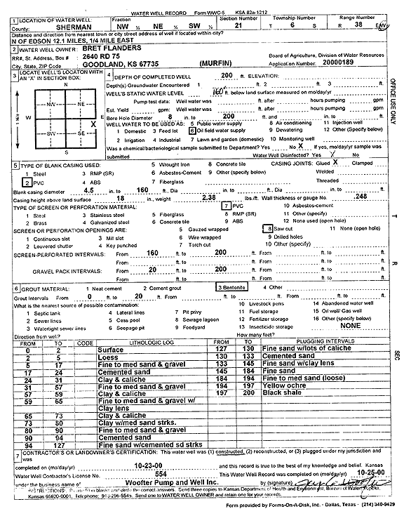
Specific Water Well Detail |
|
|
| Location Info | |||
| Owner: Flanders, Bret | Status: Constructed | ||
| Location: T6S, R38W, Sec. 21, NW NE SW | County: Sherman | ||
| Directions: 12.1 mi N of Edson, .25 mi E | |||
| Latitude: 39.5173725 | Longitude: -101.5705522 | Datum NAD 27 | |
| Latitude: 39.5173704 | Longitude: -101.5709982 | Datum NAD 83 | |
| Longitude and latitude calculated by Survey from township-range-section-quarter calls. Only good to within the quarter call accuracy. | |||
| View well on interactive map | |||
| General Info | ||
| Well Depth: 200 ft. | Elevation: ft. | |
| Static Water Level: 160 ft. | Est. Yield: gpm. | |
| Comp. Date: 23-Oct-2000 | Well Use: Oil Field Water Supply | |
| DWR Applic. #: 20000189 | Other ID: | |
| Links | |
| No Wizard information available. | |
| View info from WIMAS Water Right Data base... | |
| Driller Info | ||
| Driller: Jay C. Woofter Pump & Well, Inc. | License #: 554 | |
| Scanned Form | View scan |
|
Chemical Sample Submitted?:
Water Well disinfected?: | ||
| Casing Info | ||
| Casing Type:
Casing Joints: |
Diam: in. to ft | |
| Casing height above land surface: in
Casing Weight: lbs/ft Wall thickness or gauge no.: | ||
| Screen and Perforation Info | ||
| Screen Type: | Screen Openings: | |
| Screen-perforated intervals | From: ft to ft | |
| Gravel pack intervals | From: ft to ft | |
| Grout Info | ||
| Grout used: | From: to ft | |
| Source of Possible Contamination | ||
| Source: | ||
| Direction from well: | Distance: ft | |
| Lithologic Log
(Log data entered by KGS.) | ||
| From: 0 ft. to 2 ft. | Surface | |
| From: 2 ft. to 5 ft. | Loess | |
| From: 5 ft. to 17 ft. | Fine to medium sand and gravel | |
| From: 17 ft. to 24 ft. | Cemented sand | |
| From: 24 ft. to 31 ft. | Clay and caliche | |
| From: 31 ft. to 57 ft. | Fine to medium sand and gravel | |
| From: 57 ft. to 59 ft. | Clay and caliche | |
| From: 59 ft. to 65 ft. | Fine to medium sand and gravel with clay lens | |
| From: 65 ft. to 73 ft. | Clay and caliche | |
| From: 73 ft. to 80 ft. | Clay with medium sand streaks | |
| From: 80 ft. to 90 ft. | Fine to medium sand and gravel | |
| From: 90 ft. to 94 ft. | Cemented sand | |
| From: 94 ft. to 127 ft. | Fine sand with cemented sand streaks | |
| From: 127 ft. to 130 ft. | Fine sand with lots of caliche | |
| From: 130 ft. to 133 ft. | Cemented sand | |
| From: 133 ft. to 145 ft. | Fine sand with clay lens | |
| From: 145 ft. to 184 ft. | Fine sand | |
| From: 184 ft. to 194 ft. | Fine to medium sand (loose) | |
| From: 194 ft. to 197 ft. | Yellow ochre | |
| From: 197 ft. to 200 ft. | Black shale | |