|
|
|
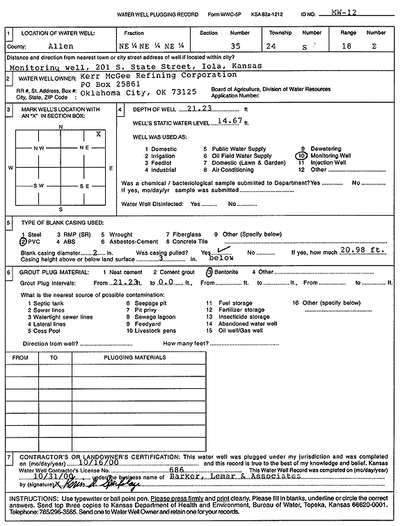
Specific Water Well Detail |
|
|
| Location Info | |||
| Owner: Kerr McGee Refining Corp | Status: Plugged | ||
| Location: T24S, R18E, Sec. 35, NE NE NE | County: Allen | ||
| Directions: 201 S State St, Iola | |||
| Latitude: 37.92119 | Longitude: -95.3916675 | Datum NAD 27 | |
| Latitude: 37.9212257 | Longitude: -95.3919267 | Datum NAD 83 | |
| Longitude and latitude calculated by Survey from township-range-section-quarter calls. Only good to within the quarter call accuracy. | |||
| View well on interactive map | |||
| General Info | ||
| Well Depth: 21.23 ft. | Elevation: ft. | |
| Static Water Level: 14.67 ft. | Est. Yield: gpm. | |
| Comp. Date: 16-Oct-2000 | Well Use: Monitoring well/observation/piezometer | |
| DWR Applic. #: | Other ID: MW 12 | |
| Driller Info | ||
| Driller: Barker, Lemar, and Assoc., Inc. | License #: 686 | |
| Scanned Form | View scan |
| Casing Info | ||
|
Casing Type:
Diam: in. Casing height above land surface: in | ||
| Grout Info | ||
| Grout used: | From: to ft | |
| Source of Possible Contamination | ||
| Source: | ||
| Direction from well: | Distance: ft | |