|
|
|
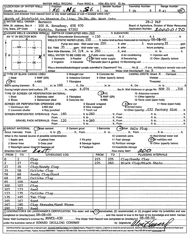
Specific Water Well Detail |
|
|
| Location Info | |||
| Owner: Berexco Inc. | Status: Constructed | ||
| Location: T29S, R41W, Sec. 28, NE NE SE | County: Stanton | ||
| Directions: N of Richfield to Stanton County line, 7 mi N, 2 mi W, 4 mi N, W into site | |||
| Latitude: 37.4968632 | Longitude: -101.7991268 | Datum NAD 27 | |
| Latitude: 37.4968815 | Longitude: -101.7995763 | Datum NAD 83 | |
| Longitude and latitude calculated by Survey from township-range-section-quarter calls. Only good to within the quarter call accuracy. | |||
| View well on interactive map | |||
| General Info | ||
| Well Depth: 260 ft. | Elevation: ft. | |
| Static Water Level: 150 ft. | Est. Yield: 35 gpm. | |
| Comp. Date: 08-Aug-2000 | Well Use: Oil Field Water Supply | |
| DWR Applic. #: 20000170 | Other ID: P and P 28-2 | |
| Links | |
| No Wizard information available. | |
| View info from WIMAS Water Right Data base... | |
| Driller Info | ||
| Driller: Howard Drilling Company AG, LLC | License #: 430 | |
| Scanned Form | View scan |
|
Chemical Sample Submitted?:
Water Well disinfected?: | ||
| Casing Info | ||
| Casing Type:
Casing Joints: |
Diam: in. to ft | |
| Casing height above land surface: in
Casing Weight: lbs/ft Wall thickness or gauge no.: | ||
| Screen and Perforation Info | ||
| Screen Type: | Screen Openings: | |
| Screen-perforated intervals | From: ft to ft | |
| Gravel pack intervals | From: ft to ft | |
| Grout Info | ||
| Grout used: | From: to ft | |
| Source of Possible Contamination | ||
| Source: | ||
| Direction from well: | Distance: ft | |
| Lithologic Log
(Log data entered by KGS.) | ||
| From: 0 ft. to 2 ft. | clay | |
| From: 2 ft. to 27 ft. | clay | |
| From: 27 ft. to 35 ft. | clay/sandy clay | |
| From: 35 ft. to 58 ft. | caliche clay | |
| From: 58 ft. to 68 ft. | sandy clay/sand | |
| From: 68 ft. to 85 ft. | caliche clay | |
| From: 85 ft. to 100 ft. | sand | |
| From: 100 ft. to 107 ft. | clay | |
| From: 107 ft. to 123 ft. | sand | |
| From: 123 ft. to 135 ft. | caliche clay | |
| From: 135 ft. to 145 ft. | tan clay | |
| From: 145 ft. to 167 ft. | sand | |
| From: 167 ft. to 190 ft. | clay streaks/sandstone | |
| From: 190 ft. to 215 ft. | sand | |
| From: 215 ft. to 225 ft. | clay/sandy clay | |
| From: 225 ft. to 260 ft. | black clay/black shale | |