|
|
|
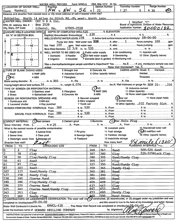
Specific Water Well Detail |
|
|
| Location Info | |||
| Owner: Oxy USA, Inc. | Status: Constructed | ||
| Location: T27S, R34W, Sec. 22, NW NW SE | County: Haskell | ||
| Directions: from Sublette: 14 mi N to Hitch Rd, 8.5 mi W, N into site | |||
| Latitude: 37.6846396 | Longitude: -101.024322 | Datum NAD 27 | |
| Latitude: 37.6846632 | Longitude: -101.0247688 | Datum NAD 83 | |
| Longitude and latitude calculated by Survey from township-range-section-quarter calls. Only good to within the quarter call accuracy. | |||
| View well on interactive map | |||
| General Info | ||
| Well Depth: 520 ft. | Elevation: ft. | |
| Static Water Level: 238 ft. | Est. Yield: 100 gpm. | |
| Comp. Date: 04-Aug-2000 | Well Use: Oil Field Water Supply | |
| DWR Applic. #: 20000182 | Other ID: Snyder C 1 | |
| Links | |
| No Wizard information available. | |
| View info from WIMAS Water Right Data base... | |
| Driller Info | ||
| Driller: Howard Drilling Company AG, LLC | License #: 430 | |
| Scanned Form | View scan |
|
Chemical Sample Submitted?:
Water Well disinfected?: | ||
| Casing Info | ||
| Casing Type:
Casing Joints: |
Diam: in. to ft | |
| Casing height above land surface: in
Casing Weight: lbs/ft Wall thickness or gauge no.: | ||
| Screen and Perforation Info | ||
| Screen Type: | Screen Openings: | |
| Screen-perforated intervals | From: ft to ft | |
| Gravel pack intervals | From: ft to ft | |
| Grout Info | ||
| Grout used: | From: to ft | |
| Source of Possible Contamination | ||
| Source: | ||
| Direction from well: | Distance: ft | |
| Lithologic Log
(Log data entered by KGS.) | ||
| From: 0 ft. to 2 ft. | clay | |
| From: 2 ft. to 38 ft. | clay | |
| From: 38 ft. to 50 ft. | clay/sandy clay | |
| From: 50 ft. to 61 ft. | sand | |
| From: 61 ft. to 87 ft. | clay | |
| From: 87 ft. to 107 ft. | sand | |
| From: 107 ft. to 127 ft. | sand/sandy clay | |
| From: 127 ft. to 158 ft. | sandy clay | |
| From: 158 ft. to 180 ft. | coarse sand | |
| From: 180 ft. to 186 ft. | clay/sandy clay | |
| From: 186 ft. to 225 ft. | coarse sand | |
| From: 225 ft. to 242 ft. | coarse sand/sandy clay | |
| From: 242 ft. to 253 ft. | clay | |
| From: 253 ft. to 260 ft. | sandy clay | |
| From: 260 ft. to 267 ft. | sand | |
| From: 267 ft. to 280 ft. | clay | |
| From: 280 ft. to 305 ft. | sand/sandy clay | |
| From: 305 ft. to 327 ft. | clay | |
| From: 327 ft. to 350 ft. | sand/sandy clay | |
| From: 350 ft. to 365 ft. | sandy clay | |
| From: 365 ft. to 381 ft. | sand | |
| From: 381 ft. to 390 ft. | clay | |
| From: 390 ft. to 405 ft. | sand | |
| From: 405 ft. to 408 ft. | clay | |
| From: 437 ft. to 447 ft. | clay | |
| From: 447 ft. to 453 ft. | sand | |
| From: 453 ft. to 460 ft. | sandy clay | |
| From: 460 ft. to 500 ft. | sandstone | |
| From: 500 ft. to 520 ft. | sand | |
| From: 520 ft. to 525 ft. | black clay | |