|
|
|
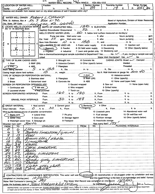
Specific Water Well Detail |
|
|
| Location Info | |||
| Owner: Calvert, Robert L. | Status: Constructed | ||
| Location: T19S, R25E, Sec. 29, SE NW SW | County: Linn | ||
| Directions: | |||
| Latitude: 38.364282 | Longitude: -94.674348 | Datum NAD 27 | |
| Latitude: 38.3643019 | Longitude: -94.6745825 | Datum NAD 83 | |
| Longitude and latitude calculated by Survey from township-range-section-quarter calls. Only good to within the quarter call accuracy. | |||
| View well on interactive map | |||
| General Info | ||
| Well Depth: 188 ft. | Elevation: ft. | |
| Static Water Level: 20 ft. | Est. Yield: 1.5 gpm. | |
| Comp. Date: 10-Oct-2000 | Well Use: Domestic | |
| DWR Applic. #: | Other ID: Well 1 | |
| Driller Info | ||
| Driller: Jesse Yoakum Well Drilling | License #: 595 | |
| Scanned Form | View scan |
|
Chemical Sample Submitted?:
Water Well disinfected?: | ||
| Casing Info | ||
| Casing Type:
Casing Joints: |
Diam: in. to ft | |
| Casing height above land surface: in
Casing Weight: lbs/ft Wall thickness or gauge no.: | ||
| Screen and Perforation Info | ||
| Screen Type: | Screen Openings: | |
| Screen-perforated intervals | From: ft to ft | |
| Gravel pack intervals | From: ft to ft | |
| Grout Info | ||
| Grout used: | From: to ft | |
| Source of Possible Contamination | ||
| Source: | ||
| Direction from well: | Distance: ft | |
| Lithologic Log
(Log data entered by KGS.) | ||
| From: 0 ft. to 6 ft. | clay | |
| From: 6 ft. to 9 ft. | broken limestone and gravel | |
| From: 9 ft. to 13 ft. | coal | |
| From: 13 ft. to 18 ft. | brown clay and shale | |
| From: 18 ft. to 26 ft. | limestone | |
| From: 26 ft. to 34 ft. | shale | |
| From: 34 ft. to 39 ft. | dark limestone | |
| From: 39 ft. to 49 ft. | shale | |
| From: 49 ft. to 52 ft. | gray limestone | |
| From: 52 ft. to 62 ft. | shale | |
| From: 62 ft. to 80 ft. | sandy gray limestone | |
| From: 80 ft. to 110 ft. | shale | |
| From: 110 ft. to 128 ft. | light gray shale | |
| From: 128 ft. to 188 ft. | dark shale | |