|
|
|
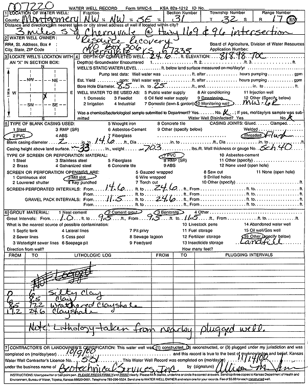
Specific Water Well Detail |
|
|
| Location Info | |||
| Owner: Resource Recovery, Inc. | Status: Constructed | ||
| Location: T32S, R17E, Sec. 31, NW NW SE | County: Montgomery | ||
| Directions: from Cherryvale: 3 mi S at Hwy 96 and Hwy 169 | |||
| Latitude: 37.2155976 | Longitude: -95.5873986 | Datum NAD 27 | |
| Latitude: 37.2156667 | Longitude: -95.5876551 | Datum NAD 83 | |
| Longitude and latitude calculated by Survey from township-range-section-quarter calls. Only good to within the quarter call accuracy. | |||
| View well on interactive map | |||
| General Info | ||
| Well Depth: 24.6 ft. | Elevation: 818.98 ft. | |
| Static Water Level: ft. | Est. Yield: gpm. | |
| Comp. Date: 09-Oct-2000 | Well Use: Monitoring well/observation/piezometer | |
| DWR Applic. #: 007220 | Other ID: MW 6 R | |
| Driller Info | ||
| Driller: Geotechnical Services, Inc. | License #: 531 | |
| Scanned Form | View scan |
|
Chemical Sample Submitted?:
Water Well disinfected?: | ||
| Casing Info | ||
| Casing Type:
Casing Joints: |
Diam: in. to ft | |
| Casing height above land surface: in
Casing Weight: lbs/ft Wall thickness or gauge no.: | ||
| Screen and Perforation Info | ||
| Screen Type: | Screen Openings: | |
| Screen-perforated intervals | From: ft to ft | |
| Gravel pack intervals | From: ft to ft | |
| Grout Info | ||
| Grout used: | From: to ft | |
| Source of Possible Contamination | ||
| Source: | ||
| Direction from well: | Distance: ft | |
| Lithologic Log
(Log data entered by KGS.) | ||
| From: 0 ft. to 6 ft. | silty clay | |
| From: 6 ft. to 8.5 ft. | clay | |
| From: 8.5 ft. to 17.2 ft. | weathered clay shale | |
| From: 17.2 ft. to 24.6 ft. | clay shale | |