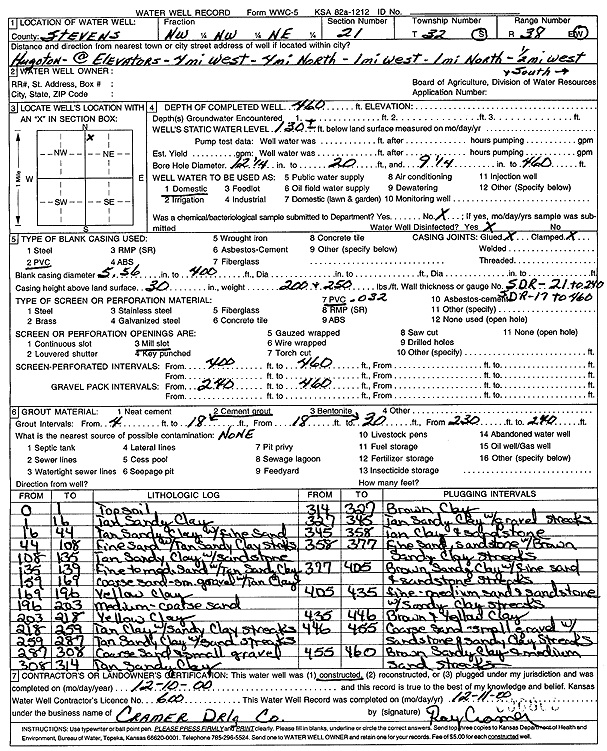
![]() |
![]() |
Specific Water Well Detail |
![]() |
Location Info | |||
Owner: unknown | Status: Constructed | ||
Location: T32S, R38W, Sec. 21, NW NW NE | County: Stevens | ||
Directions: from Hugoton elevators: 4 mi W, 4 mi N, 1 mi W, 1 mi N, .5 mi W, S into site | |||
Latitude: 37.2563101 | Longitude: -101.4552037 | Datum NAD 27 | |
Latitude: 37.2563341 | Longitude: -101.4556392 | Datum NAD 83 | |
Longitude and latitude calculated by Survey from township-range-section-quarter calls. Only good to within the quarter call accuracy. | |||
View well on interactive map |
General Info | ||
Well Depth: 460 ft. | Elevation: ft. | |
Static Water Level: 130 ft. | Est. Yield: gpm. | |
Comp. Date: 10-Dec-2000 | Well Use: Domestic | |
DWR Applic. #: | Other ID: |
Driller Info | ||
Driller: Cramer Drilling Co. | License #: 600 |
Scanned Form | ||
View form(s) on screen | Download scan(s) | |
The download files contain one or more TIFF images compressed into a ZIP archive. Your browser may be already set up to decompress these files. The TIFFs are 300 dpi archival-quality scans of the WWC5 forms and can be viewed by software like Adobe PhotoShop. |
Chemical Sample Submitted?:
Water Well disinfected?: | ||
Casing Info | ||
Casing Type:
Casing Joints: |
Diam: in. to ft | |
Casing height above land surface: in
Casing Weight: lbs/ft Wall thickness or gauge no.: |
Screen and Perforation Info | ||
Screen Type: | Screen Openings: | |
Screen-perforated intervals | From: ft to ft | |
Gravel pack intervals | From: ft to ft |
Grout Info | ||
Grout used: | From: to ft |
Source of Possible Contamination | ||
Source: | ||
Direction from well: | Distance: ft |
Lithologic Log
(Log data entered by KGS.) | ||
From: 0 ft. to 1 ft. | topsoil | |
From: 1 ft. to 16 ft. | tan sandy clay | |
From: 16 ft. to 44 ft. | tan sandy clay with fine sand | |
From: 44 ft. to 108 ft. | fine sand with tan sandy clay streaks | |
From: 108 ft. to 135 ft. | tan sandy clay with sandstone | |
From: 135 ft. to 139 ft. | fine to medium sand with tan sandy clay | |
From: 139 ft. to 169 ft. | coarse sand- small gravel with tan clay | |
From: 169 ft. to 196 ft. | yellow clay | |
From: 196 ft. to 203 ft. | medium-coarse sand | |
From: 203 ft. to 218 ft. | yellow clay | |
From: 218 ft. to 259 ft. | tan clay with sandy clay streaks | |
From: 259 ft. to 287 ft. | tan sandy clay with sand streaks | |
From: 287 ft. to 308 ft. | coarse sand and small gravel | |
From: 308 ft. to 314 ft. | tan sandy clay | |
From: 314 ft. to 327 ft. | brown clay | |
From: 327 ft. to 345 ft. | tan sandy clay with gravel streaks | |
From: 345 ft. to 358 ft. | tan clay and sandstone | |
From: 358 ft. to 377 ft. | fine sand, sandstone with brown sandy clay streaks | |
From: 377 ft. to 405 ft. | brown sandy clay with fine sand and sandstone streaks | |
From: 405 ft. to 435 ft. | fine-medium sand and sandstone with sandy clay streaks | |
From: 435 ft. to 446 ft. | brown and yellow clay | |
From: 446 ft. to 455 ft. | coarse sand- small gravel with sandstone and sandy clay streaks | |
From: 455 ft. to 460 ft. | brown sandy clay and medium sand streaks |