|
|
|
Specific Water Well Detail |
|
|
| Location Info | |||
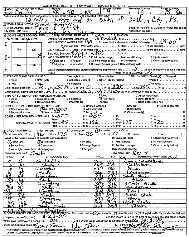
| Owner: Steve Huffman | Status: Constructed | ||
| Location: T15S, R18E, Sec. 4, SE SE NE | County: Douglas | ||
| Directions: from Baldwin City, 12 mi W and 0.5 mi S | |||
| Latitude: 38.7761294 | Longitude: -95.4097568 | Datum NAD 27 | |
| Latitude: 38.7761352 | Longitude: -95.4100116 | Datum NAD 83 | |
| Longitude and latitude calculated by Survey from township-range-section-quarter calls. Only good to within the quarter call accuracy. | |||
| View well on interactive map | |||
| General Info | ||
| Well Depth: 385 ft. | Elevation: ft. | |
| Static Water Level: 195 ft. | Est. Yield: gpm. | |
| Comp. Date: 29-Nov-2000 | Well Use: Domestic | |
| DWR Applic. #: | Other ID: | |
| Driller Info | ||
| Driller: Evans Energy Development, Inc. | License #: 561 | |
| Scanned Form | View scan |
|
Chemical Sample Submitted?:
Water Well disinfected?: | ||
| Casing Info | ||
| Casing Type:
Casing Joints: |
Diam: in. to ft | |
| Casing height above land surface: in
Casing Weight: lbs/ft Wall thickness or gauge no.: | ||
| Screen and Perforation Info | ||
| Screen Type: | Screen Openings: | |
| Screen-perforated intervals | From: ft to ft | |
| Gravel pack intervals | From: ft to ft | |
| Grout Info | ||
| Grout used: | From: to ft | |
| Source of Possible Contamination | ||
| Source: | ||
| Direction from well: | Distance: ft | |
| Lithologic Log
(Log data entered by KGS.) | ||
| From: 0 ft. to 5 ft. | Soil and Clay | |
| From: 5 ft. to 10 ft. | Shale | |
| From: 10 ft. to 14 ft. | Limestone | |
| From: 14 ft. to 48 ft. | Shale | |
| From: 48 ft. to 54 ft. | Limestone | |
| From: 54 ft. to 65 ft. | Shale | |
| From: 65 ft. to 83 ft. | Limestone | |
| From: 83 ft. to 87 ft. | Shale | |
| From: 87 ft. to 89 ft. | Limestone | |
| From: 89 ft. to 98 ft. | Shale | |
| From: 98 ft. to 107 ft. | Limestone | |
| From: 107 ft. to 165 ft. | Shale | |
| From: 165 ft. to 195 ft. | Sandy shale | |
| From: 195 ft. to 263 ft. | Fine sandstone | |
| From: 263 ft. to 269 ft. | Limey sandstone | |
| From: 269 ft. to 279 ft. | Sandstone | |
| From: 279 ft. to 280 ft. | Shale | |
| From: 280 ft. to 291 ft. | Limestone | |
| From: 291 ft. to 295 ft. | Sandy shale | |
| From: 295 ft. to 303 ft. | Shale | |
| From: 303 ft. to 318 ft. | Sandy shale | |
| From: 318 ft. to 338 ft. | Sandstone | |
| From: 338 ft. to 339 ft. | Conglomerate | |
| From: 339 ft. to 347 ft. | Sandy shale | |
| From: 347 ft. to 365 ft. | Shale | |
| From: 365 ft. to 367 ft. | Black shale | |
| From: 367 ft. to 385 ft. | Shale | |