|
|
|
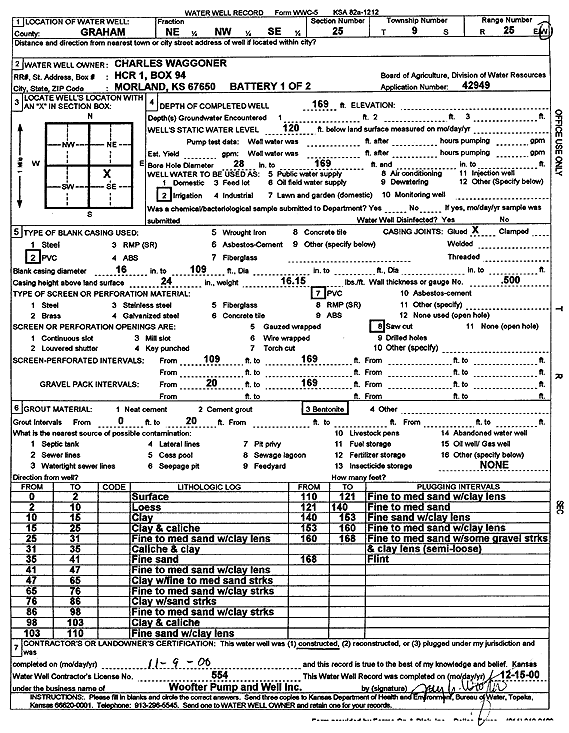
Specific Water Well Detail |
|
|
| Location Info | |||
| Owner: Waggoner, Charles | Status: Constructed | ||
| Location: T9S, R25W, Sec. 25, NE NW SE | County: Graham | ||
| Directions: | |||
| Latitude: 39.239801 | Longitude: -100.0571687 | Datum NAD 27 | |
| Latitude: 39.2398061 | Longitude: -100.0575751 | Datum NAD 83 | |
| Longitude and latitude calculated by Survey from township-range-section-quarter calls. Only good to within the quarter call accuracy. | |||
| View well on interactive map | |||
| General Info | ||
| Well Depth: 169 ft. | Elevation: ft. | |
| Static Water Level: 120 ft. | Est. Yield: gpm. | |
| Comp. Date: 09-Nov-2000 | Well Use: Irrigation | |
| DWR Applic. #: 42949 | Other ID: Battery 1 of 2 | |
| Driller Info | ||
| Driller: Jay C. Woofter Pump & Well, Inc. | License #: 554 | |
| Scanned Form | View scan |
|
Chemical Sample Submitted?:
Water Well disinfected?: | ||
| Casing Info | ||
| Casing Type:
Casing Joints: |
Diam: in. to ft | |
| Casing height above land surface: in
Casing Weight: lbs/ft Wall thickness or gauge no.: | ||
| Screen and Perforation Info | ||
| Screen Type: | Screen Openings: | |
| Screen-perforated intervals | From: ft to ft | |
| Gravel pack intervals | From: ft to ft | |
| Grout Info | ||
| Grout used: | From: to ft | |
| Source of Possible Contamination | ||
| Source: | ||
| Direction from well: | Distance: ft | |
| Lithologic Log
(Log data entered by KGS.) | ||
| From: 0 ft. to 2 ft. | surface | |
| From: 2 ft. to 10 ft. | loess | |
| From: 10 ft. to 15 ft. | clay | |
| From: 15 ft. to 25 ft. | clay and caliche | |
| From: 25 ft. to 31 ft. | fine to medium sand with clay lens | |
| From: 31 ft. to 35 ft. | caliche and clay | |
| From: 35 ft. to 41 ft. | fine sand | |
| From: 41 ft. to 47 ft. | fine to medium sand with clay lens | |
| From: 47 ft. to 65 ft. | clay with fine to medium sand streaks | |
| From: 65 ft. to 76 ft. | fine to medium sand with clay streaks | |
| From: 76 ft. to 86 ft. | clay with sand streaks | |
| From: 86 ft. to 98 ft. | fine to medium sand with clay streaks | |
| From: 98 ft. to 103 ft. | clay and caliche | |
| From: 103 ft. to 110 ft. | fine sand with clay lens | |
| From: 110 ft. to 121 ft. | fine to medium sand with clay lens | |
| From: 121 ft. to 140 ft. | fine to medium sand | |
| From: 140 ft. to 153 ft. | fine sand with clay lens | |
| From: 153 ft. to 160 ft. | fine to medium sand with clay lens | |
| From: 160 ft. to 168 ft. | fine to medium sand with some gravel streaks and clay lens (semi-loose) | |
| From: 168 ft. to ft. | flint | |