|
|
|
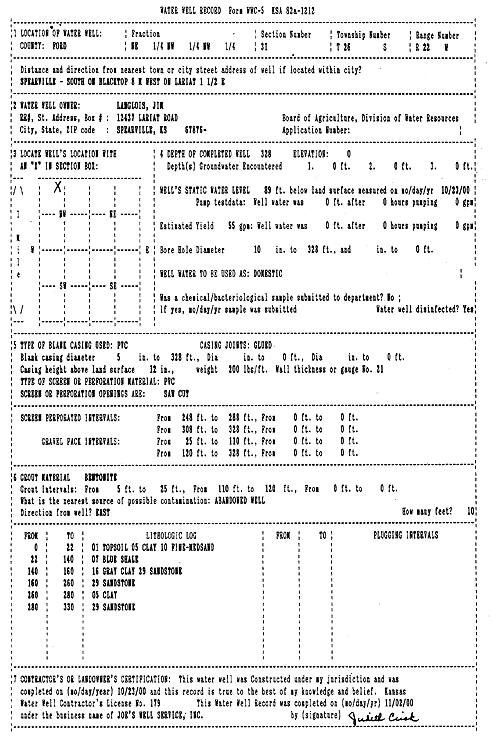
Specific Water Well Detail |
|
|
| Location Info | |||
| Owner: Langlois, Jim | Status: Constructed | ||
| Location: T26S, R22W, Sec. 31, NE NW NW | County: Ford | ||
| Directions: from Spearville: S on blacktop, 8 mi W on Lariat, 1.5 mi E | |||
| Latitude: 37.7480543 | Longitude: -99.7747146 | Datum NAD 27 | |
| Latitude: 37.7480739 | Longitude: -99.7751199 | Datum NAD 83 | |
| Longitude and latitude calculated by Survey from township-range-section-quarter calls. Only good to within the quarter call accuracy. | |||
| View well on interactive map | |||
| General Info | ||
| Well Depth: 328 ft. | Elevation: ft. | |
| Static Water Level: 89 ft. | Est. Yield: 55 gpm. | |
| Comp. Date: 23-Oct-2000 | Well Use: Domestic | |
| DWR Applic. #: | Other ID: | |
| Driller Info | ||
| Driller: Joe's Well Service, Inc. | License #: 179 | |
| Scanned Form | View scan |
|
Chemical Sample Submitted?:
Water Well disinfected?: | ||
| Casing Info | ||
| Casing Type:
Casing Joints: |
Diam: in. to ft | |
| Casing height above land surface: in
Casing Weight: lbs/ft Wall thickness or gauge no.: | ||
| Screen and Perforation Info | ||
| Screen Type: | Screen Openings: | |
| Screen-perforated intervals | From: ft to ft | |
| Gravel pack intervals | From: ft to ft | |
| Grout Info | ||
| Grout used: | From: to ft | |
| Source of Possible Contamination | ||
| Source: | ||
| Direction from well: | Distance: ft | |
| Lithologic Log
(Log data entered by KGS.) | ||
| From: 0 ft. to 22 ft. | topsoil clay fine to medium sand | |
| From: 22 ft. to 140 ft. | blue shale | |
| From: 140 ft. to 160 ft. | gray clay sandstone | |
| From: 160 ft. to 260 ft. | sandstone | |
| From: 260 ft. to 280 ft. | clay | |
| From: 280 ft. to 330 ft. | sandstone | |