|
|
|
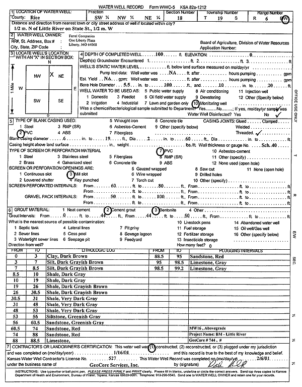
Specific Water Well Detail |
|
|
| Location Info | |||
| Owner: Ferrell Companies | Status: Constructed | ||
| Location: T19S, R6W, Sec. 18, SW NW NE | County: Rice | ||
| Directions: from Little River: .5 mi N on State St, .5 mi W | |||
| Latitude: 38.4029761 | Longitude: -98.0244308 | Datum NAD 27 | |
| Latitude: 38.4029857 | Longitude: -98.0247612 | Datum NAD 83 | |
| Longitude and latitude calculated by Survey from township-range-section-quarter calls. Only good to within the quarter call accuracy. | |||
| View well on interactive map | |||
| General Info | ||
| Well Depth: 100 ft. | Elevation: ft. | |
| Static Water Level: ft. | Est. Yield: gpm. | |
| Comp. Date: 16-Jan-2001 | Well Use: Monitoring well/observation/piezometer | |
| DWR Applic. #: | Other ID: MW 16 | |
| Driller Info | ||
| Driller: GeoCore Services Inc. | License #: 527 | |
| Scanned Form | View scan |
|
Chemical Sample Submitted?:
Water Well disinfected?: | ||
| Casing Info | ||
| Casing Type:
Casing Joints: |
Diam: in. to ft | |
| Casing height above land surface: in
Casing Weight: lbs/ft Wall thickness or gauge no.: | ||
| Screen and Perforation Info | ||
| Screen Type: | Screen Openings: | |
| Screen-perforated intervals | From: ft to ft | |
| Gravel pack intervals | From: ft to ft | |
| Grout Info | ||
| Grout used: | From: to ft | |
| Source of Possible Contamination | ||
| Source: | ||
| Direction from well: | Distance: ft | |
| Lithologic Log
(Log data entered by KGS.) | ||
| From: 0 ft. to 3 ft. | clay, dark brown | |
| From: 3 ft. to 7 ft. | silt, dark grayish brown | |
| From: 7 ft. to 8.5 ft. | silt, dark grayish brown | |
| From: 8.5 ft. to 10 ft. | shale, dark gray | |
| From: 10 ft. to 19 ft. | shale, dark gray | |
| From: 19 ft. to 26 ft. | shale, dark grayish brown | |
| From: 26 ft. to 30.5 ft. | shale, dark grayish brown | |
| From: 30.5 ft. to 31 ft. | shale, very dark gray | |
| From: 31 ft. to 48 ft. | shale, very dark gray | |
| From: 48 ft. to 53 ft. | shale, very dark gray | |
| From: 53 ft. to 56 ft. | siltstone, greenish gray | |
| From: 56 ft. to 60.5 ft. | sandstone, greenish gray | |
| From: 60.5 ft. to 74 ft. | sandstone, red | |
| From: 74 ft. to 88 ft. | sandstone, red | |
| From: 88 ft. to 88.5 ft. | limestone | |
| From: 88.5 ft. to 95 ft. | sandstone, red | |
| From: 95 ft. to 98.5 ft. | limestone, gray | |
| From: 98.5 ft. to 99.2 ft. | limestone, gray | |