|
|
|
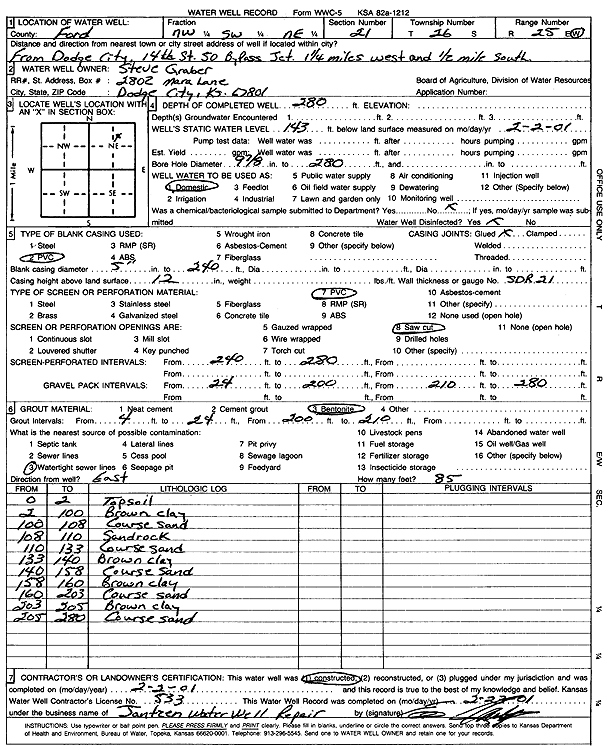
Specific Water Well Detail |
|
|
| Location Info | |||
| Owner: Graber, Steve | Status: Constructed | ||
| Location: T26S, R25W, Sec. 21, NW SW NE | County: Ford | ||
| Directions: from Dodge City; 14th St and 50 bypass Jct., 1.25 mi W and 0.5 mi S | |||
| Latitude: 37.775691 | Longitude: -100.0589848 | Datum NAD 27 | |
| Latitude: 37.7757113 | Longitude: -100.0593981 | Datum NAD 83 | |
| Longitude and latitude calculated by Survey from township-range-section-quarter calls. Only good to within the quarter call accuracy. | |||
| View well on interactive map | |||
| General Info | ||
| Well Depth: 280 ft. | Elevation: ft. | |
| Static Water Level: 143 ft. | Est. Yield: gpm. | |
| Comp. Date: 02-Feb-2001 | Well Use: Domestic | |
| DWR Applic. #: | Other ID: | |
| Driller Info | ||
| Driller: Ed Jantzen Water Well Repair | License #: 533 | |
| Scanned Form | View scan |
|
Chemical Sample Submitted?:
Water Well disinfected?: | ||
| Casing Info | ||
| Casing Type:
Casing Joints: |
Diam: in. to ft | |
| Casing height above land surface: in
Casing Weight: lbs/ft Wall thickness or gauge no.: | ||
| Screen and Perforation Info | ||
| Screen Type: | Screen Openings: | |
| Screen-perforated intervals | From: ft to ft | |
| Gravel pack intervals | From: ft to ft | |
| Grout Info | ||
| Grout used: | From: to ft | |
| Source of Possible Contamination | ||
| Source: | ||
| Direction from well: | Distance: ft | |
| Lithologic Log
(Log data entered by KGS.) | ||
| From: 0 ft. to 2 ft. | topsoil | |
| From: 2 ft. to 100 ft. | brown clay | |
| From: 100 ft. to 108 ft. | coarse sand | |
| From: 108 ft. to 110 ft. | sandrock | |
| From: 110 ft. to 133 ft. | coarse sand | |
| From: 133 ft. to 140 ft. | brown clay | |
| From: 140 ft. to 158 ft. | coarse sand | |
| From: 158 ft. to 160 ft. | brown clay | |
| From: 160 ft. to 203 ft. | coarse sand | |
| From: 203 ft. to 205 ft. | brown clay | |
| From: 205 ft. to 280 ft. | coarse sand | |