|
|
|
Specific Water Well Detail |
|
|
| Location Info | |||
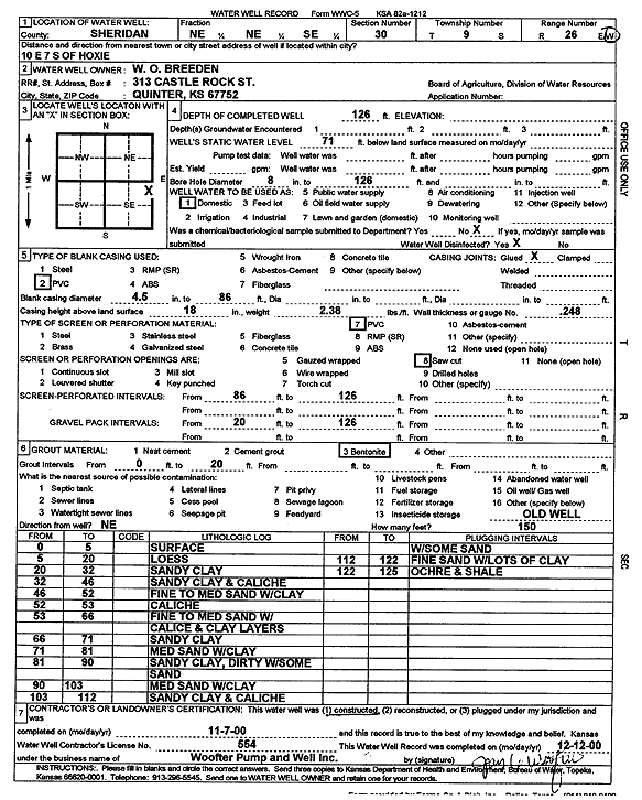
| Owner: Breeden, W.O. | Status: Constructed | ||
| Location: T9S, R26W, Sec. 30, NE NE SE | County: Sheridan | ||
| Directions: from Hoxie: 10 mi E, 7 mi S | |||
| Latitude: 39.2400587 | Longitude: -100.2576362 | Datum NAD 27 | |
| Latitude: 39.2400636 | Longitude: -100.2580496 | Datum NAD 83 | |
| Longitude and latitude calculated by Survey from township-range-section-quarter calls. Only good to within the quarter call accuracy. | |||
| View well on interactive map | |||
| General Info | ||
| Well Depth: 126 ft. | Elevation: ft. | |
| Static Water Level: 71 ft. | Est. Yield: gpm. | |
| Comp. Date: 07-Nov-2000 | Well Use: Domestic | |
| DWR Applic. #: | Other ID: | |
| Driller Info | ||
| Driller: Jay C. Woofter Pump & Well, Inc. | License #: 554 | |
| Scanned Form | View scan |
|
Chemical Sample Submitted?:
Water Well disinfected?: | ||
| Casing Info | ||
| Casing Type:
Casing Joints: |
Diam: in. to ft | |
| Casing height above land surface: in
Casing Weight: lbs/ft Wall thickness or gauge no.: | ||
| Screen and Perforation Info | ||
| Screen Type: | Screen Openings: | |
| Screen-perforated intervals | From: ft to ft | |
| Gravel pack intervals | From: ft to ft | |
| Grout Info | ||
| Grout used: | From: to ft | |
| Source of Possible Contamination | ||
| Source: | ||
| Direction from well: | Distance: ft | |
| Lithologic Log
(Log data entered by KGS.) | ||
| From: 0 ft. to 5 ft. | Surface | |
| From: 5 ft. to 20 ft. | Loess | |
| From: 20 ft. to 32 ft. | Sandy clay | |
| From: 32 ft. to 46 ft. | Sandy clay and caliche | |
| From: 46 ft. to 52 ft. | Fine to medium sand with clay | |
| From: 52 ft. to 53 ft. | Caliche | |
| From: 53 ft. to 66 ft. | Fine to medium sand with caliche and clay layers | |
| From: 66 ft. to 71 ft. | Sandy clay | |
| From: 71 ft. to 81 ft. | Medium sand with clay | |
| From: 81 ft. to 90 ft. | Sandy clay, dirty with some sand | |
| From: 90 ft. to 103 ft. | Medium sand with clay | |
| From: 103 ft. to 112 ft. | Sandy clay and caliche with some sand | |
| From: 112 ft. to 122 ft. | Fine sand with lots of clay | |
| From: 122 ft. to 125 ft. | Ochre and shale | |