|
|
|
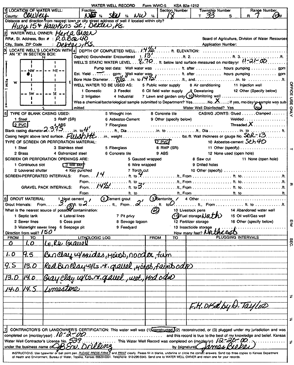
Specific Water Well Detail |
|
|
| Location Info | |||
| Owner: Greer, Merla | Status: Constructed | ||
| Location: T33S, R7E, Sec. 18, NE SW NW | County: Cowley | ||
| Directions: Hwy 15 and Hawkins St, Dexter | |||
| Latitude: 37.1823713 | Longitude: -96.7118932 | Datum NAD 27 | |
| Latitude: 37.1824003 | Longitude: -96.7121986 | Datum NAD 83 | |
| Longitude and latitude calculated by Survey from township-range-section-quarter calls. Only good to within the quarter call accuracy. | |||
| View well on interactive map | |||
| General Info | ||
| Well Depth: 14.5 ft. | Elevation: ft. | |
| Static Water Level: 8.7 ft. | Est. Yield: gpm. | |
| Comp. Date: 02-Oct-2000 | Well Use: Monitoring well/observation/piezometer | |
| DWR Applic. #: | Other ID: MW 8 | |
| Driller Info | ||
| Driller: JB Environmental Drilling | License #: 539 | |
| Scanned Form | View scan |
|
Chemical Sample Submitted?:
Water Well disinfected?: | ||
| Casing Info | ||
| Casing Type:
Casing Joints: |
Diam: in. to ft | |
| Casing height above land surface: in
Casing Weight: lbs/ft Wall thickness or gauge no.: | ||
| Screen and Perforation Info | ||
| Screen Type: | Screen Openings: | |
| Screen-perforated intervals | From: ft to ft | |
| Gravel pack intervals | From: ft to ft | |
| Grout Info | ||
| Grout used: | From: to ft | |
| Source of Possible Contamination | ||
| Source: | ||
| Direction from well: | Distance: ft | |
| Lithologic Log
(Log data entered by KGS.) | ||
| From: 0 ft. to 1 ft. | limestone rock gravel | |
| From: 1 ft. to 9.5 ft. | brown clay with oxides, moist, no odor, firm | |
| From: 9.5 ft. to 13 ft. | red brown clay with limestone rock gravel, moist, faint odor | |
| From: 13 ft. to 14 ft. | gray clay with limestone rock gravel, wet, moderate odor | |
| From: 14 ft. to 14.5 ft. | limestone | |