|
|
|
Specific Water Well Detail |
|
|
| Location Info | |||
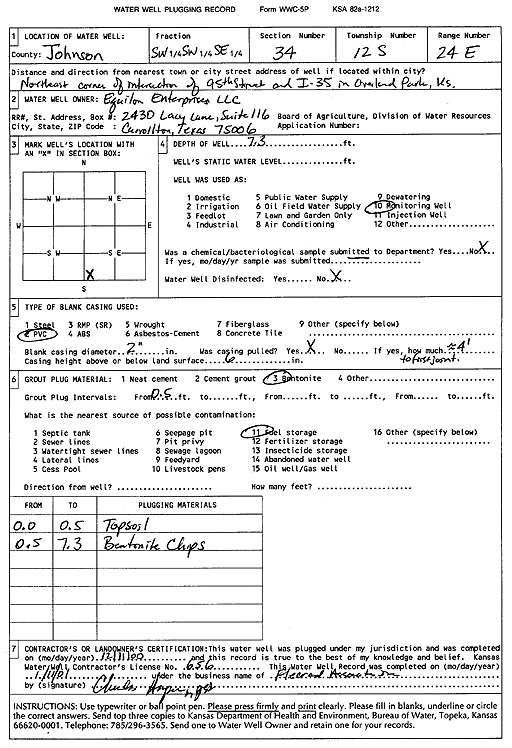
| Owner: Equilon Enterprises, LLC | Status: Plugged | ||
| Location: T12S, R24E, Sec. 34, SW SW SE | County: Johnson | ||
| Directions: NE corner of 95th St and I-35 in Overland Park | |||
| Latitude: 38.9573624 | Longitude: -94.7315296 | Datum NAD 27 | |
| Latitude: 38.9573687 | Longitude: -94.7317673 | Datum NAD 83 | |
| Longitude and latitude calculated by Survey from township-range-section-quarter calls. Only good to within the quarter call accuracy. | |||
| View well on interactive map | |||
| General Info | ||
| Well Depth: 7.3 ft. | Elevation: ft. | |
| Static Water Level: ft. | Est. Yield: gpm. | |
| Comp. Date: 11-Dec-2000 | Well Use: Monitoring well/observation/piezometer | |
| DWR Applic. #: | Other ID: | |
| Driller Info | ||
| Driller: Fleer & Assoc., Inc. | License #: 656 | |
| Scanned Form | View scan |
| Casing Info | ||
|
Casing Type:
Diam: in. Casing height above land surface: in | ||
| Grout Info | ||
| Grout used: | From: to ft | |
| Source of Possible Contamination | ||
| Source: | ||
| Direction from well: | Distance: ft | |