|
|
|
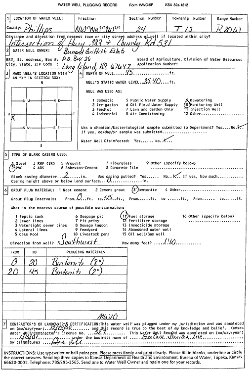
Specific Water Well Detail |
|
|
| Location Info | |||
| Owner: Bernard Griffith Estate | Status: Plugged | ||
| Location: T1S, R20W, Sec. 24, NW NW SW | County: Phillips | ||
| Directions: Intersection of Hwy 383 and County Road 531 | |||
| Latitude: 39.9503951 | Longitude: -99.5325244 | Datum NAD 27 | |
| Latitude: 39.9504044 | Longitude: -99.5329075 | Datum NAD 83 | |
| Longitude and latitude calculated by Survey from township-range-section-quarter calls. Only good to within the quarter call accuracy. | |||
| View well on interactive map | |||
| General Info | ||
| Well Depth: 45 ft. | Elevation: ft. | |
| Static Water Level: 35.4 ft. | Est. Yield: gpm. | |
| Comp. Date: 28-Dec-2000 | Well Use: Monitoring well/observation/piezometer | |
| DWR Applic. #: | Other ID: MW 10 | |
| Driller Info | ||
| Driller: GeoCore Services Inc. | License #: 527 | |
| Scanned Form | View scan |
| Casing Info | ||
|
Casing Type:
Diam: in. Casing height above land surface: in | ||
| Grout Info | ||
| Grout used: | From: to ft | |
| Source of Possible Contamination | ||
| Source: | ||
| Direction from well: | Distance: ft | |