|
|
|
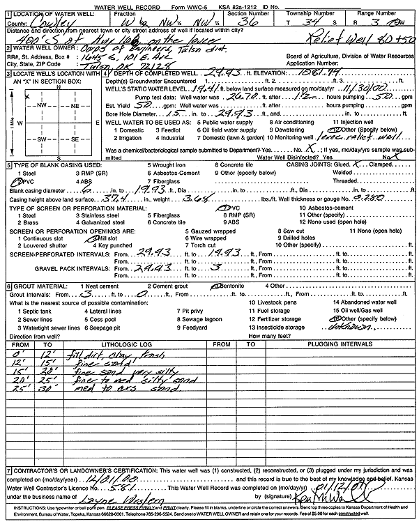
Specific Water Well Detail |
|
|
| Location Info | |||
| Owner: Corps of Engineers, Tulsa Dist. | Status: Constructed | ||
| Location: T34S, R3E, Sec. 36, W2 NW NW | County: Cowley | ||
| Directions: 400' S of Hwy 166 on the levee | |||
| Latitude: 37.0545914 | Longitude: -97.0562627 | Datum NAD 27 | |
| Latitude: 37.0546205 | Longitude: -97.0565789 | Datum NAD 83 | |
| Longitude and latitude calculated by Survey from township-range-section-quarter calls. Only good to within the quarter call accuracy. | |||
| View well on interactive map | |||
| General Info | ||
| Well Depth: 29.93 ft. | Elevation: 1081.74 ft. | |
| Static Water Level: 19.41 ft. | Est. Yield: 50 gpm. | |
| Comp. Date: 01-Dec-2000 | Well Use: Other | |
| DWR Applic. #: | Other ID: Relief Well 80+50 | |
| Driller Info | ||
| Driller: Layne Western | License #: 581 | |
| Scanned Form | View scan |
|
Chemical Sample Submitted?:
Water Well disinfected?: | ||
| Casing Info | ||
| Casing Type:
Casing Joints: |
Diam: in. to ft | |
| Casing height above land surface: in
Casing Weight: lbs/ft Wall thickness or gauge no.: | ||
| Screen and Perforation Info | ||
| Screen Type: | Screen Openings: | |
| Screen-perforated intervals | From: ft to ft | |
| Gravel pack intervals | From: ft to ft | |
| Grout Info | ||
| Grout used: | From: to ft | |
| Source of Possible Contamination | ||
| Source: | ||
| Direction from well: | Distance: ft | |
| Lithologic Log
(Log data entered by KGS.) | ||
| From: 0 ft. to 12 ft. | fill dirt, clay, trash | |
| From: 12 ft. to 15 ft. | fine sand | |
| From: 15 ft. to 20 ft. | fine sand, very silty | |
| From: 20 ft. to 25 ft. | fine to medium silty sand | |
| From: 25 ft. to 30 ft. | medium to coarse sand | |