|
|
|
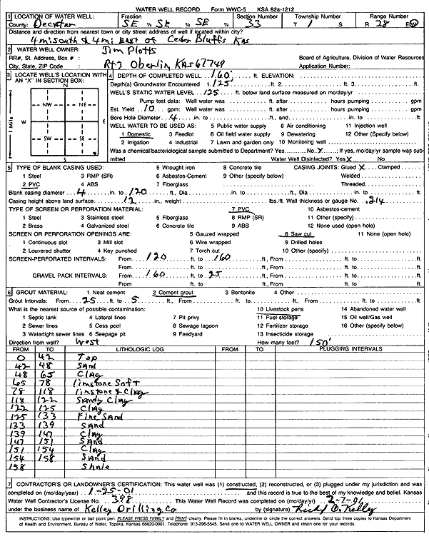
Specific Water Well Detail |
|
|
| Location Info | |||
| Owner: Plotts, Jim | Status: Constructed | ||
| Location: T1S, R28W, Sec. 33, SE SE SE | County: Decatur | ||
| Directions: from Cedar Bluffs, 4 mi S and 4 mi E | |||
| Latitude: 39.9159118 | Longitude: -100.4603716 | Datum NAD 27 | |
| Latitude: 39.9159175 | Longitude: -100.4607943 | Datum NAD 83 | |
| Longitude and latitude calculated by Survey from township-range-section-quarter calls. Only good to within the quarter call accuracy. | |||
| View well on interactive map | |||
| General Info | ||
| Well Depth: 160 ft. | Elevation: ft. | |
| Static Water Level: 125 ft. | Est. Yield: 10 gpm. | |
| Comp. Date: 25-Jan-2001 | Well Use: Domestic | |
| DWR Applic. #: | Other ID: | |
| Driller Info | ||
| Driller: Richard O. Kelley Drilling Co. | License #: 398 | |
| Scanned Form | View scan |
|
Chemical Sample Submitted?:
Water Well disinfected?: | ||
| Casing Info | ||
| Casing Type:
Casing Joints: |
Diam: in. to ft | |
| Casing height above land surface: in
Casing Weight: lbs/ft Wall thickness or gauge no.: | ||
| Screen and Perforation Info | ||
| Screen Type: | Screen Openings: | |
| Screen-perforated intervals | From: ft to ft | |
| Gravel pack intervals | From: ft to ft | |
| Grout Info | ||
| Grout used: | From: to ft | |
| Source of Possible Contamination | ||
| Source: | ||
| Direction from well: | Distance: ft | |
| Lithologic Log
(Log data entered by KGS.) | ||
| From: 0 ft. to 42 ft. | top | |
| From: 42 ft. to 48 ft. | sand | |
| From: 48 ft. to 65 ft. | clay | |
| From: 65 ft. to 78 ft. | limestone soft | |
| From: 78 ft. to 118 ft. | limestone and clay | |
| From: 118 ft. to 122 ft. | sandy clay | |
| From: 122 ft. to 125 ft. | clay | |
| From: 125 ft. to 133 ft. | fine sand | |
| From: 133 ft. to 139 ft. | sand | |
| From: 139 ft. to 147 ft. | clay | |
| From: 147 ft. to 151 ft. | sand | |
| From: 151 ft. to 154 ft. | clay | |
| From: 154 ft. to 158 ft. | sand | |
| From: 158 ft. to ft. | shale | |