|
|
|
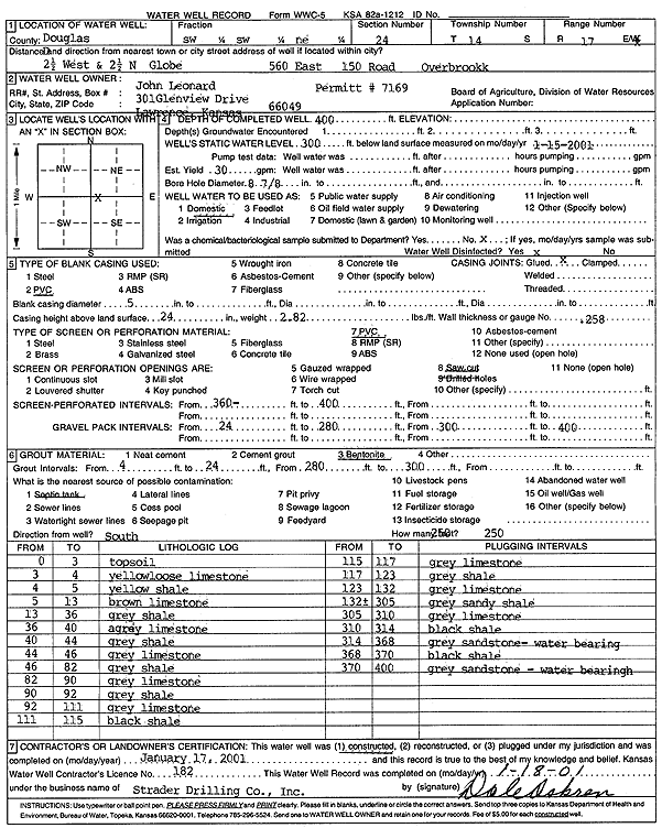
Specific Water Well Detail |
|
|
| Location Info | |||
| Owner: Leonard, John | Status: Constructed | ||
| Location: T14S, R17E, Sec. 24, SW SW NE | County: Douglas | ||
| Directions: from Globe: 2.5 mi W, 2.5 mi N - 560 E 150 Rd, Overbrook | |||
| Latitude: 38.8197459 | Longitude: -95.4714076 | Datum NAD 27 | |
| Latitude: 38.8197504 | Longitude: -95.4716634 | Datum NAD 83 | |
| Longitude and latitude calculated by Survey from township-range-section-quarter calls. Only good to within the quarter call accuracy. | |||
| View well on interactive map | |||
| General Info | ||
| Well Depth: 400 ft. | Elevation: ft. | |
| Static Water Level: 300 ft. | Est. Yield: 30 gpm. | |
| Comp. Date: 17-Jan-2001 | Well Use: Domestic | |
| DWR Applic. #: | Other ID: | |
| Driller Info | ||
| Driller: Strader Drilling Co., Inc. | License #: 182 | |
| Scanned Form | View scan |
|
Chemical Sample Submitted?:
Water Well disinfected?: | ||
| Casing Info | ||
| Casing Type:
Casing Joints: |
Diam: in. to ft | |
| Casing height above land surface: in
Casing Weight: lbs/ft Wall thickness or gauge no.: | ||
| Screen and Perforation Info | ||
| Screen Type: | Screen Openings: | |
| Screen-perforated intervals | From: ft to ft | |
| Gravel pack intervals | From: ft to ft | |
| Grout Info | ||
| Grout used: | From: to ft | |
| Source of Possible Contamination | ||
| Source: | ||
| Direction from well: | Distance: ft | |
| Lithologic Log
(Log data entered by KGS.) | ||
| From: 0 ft. to 3 ft. | Top soil | |
| From: 3 ft. to 4 ft. | Yellow loose limestone | |
| From: 4 ft. to 5 ft. | Yellow shale | |
| From: 5 ft. to 13 ft. | Brown limestone | |
| From: 13 ft. to 36 ft. | Gray shale | |
| From: 36 ft. to 40 ft. | Gray limestone | |
| From: 40 ft. to 44 ft. | Gray shale | |
| From: 44 ft. to 46 ft. | Gray limestone | |
| From: 46 ft. to 82 ft. | Gray shale | |
| From: 82 ft. to 90 ft. | Gray limestone | |
| From: 90 ft. to 92 ft. | Gray shale | |
| From: 92 ft. to 111 ft. | Gray limestone | |
| From: 111 ft. to 115 ft. | Black shale | |
| From: 115 ft. to 117 ft. | Gray limestone | |
| From: 117 ft. to 123 ft. | Gray shale | |
| From: 123 ft. to 132 ft. | Gray limestone | |
| From: 132 ft. to 305 ft. | Gray sandy shale | |
| From: 305 ft. to 310 ft. | Gray limestone | |
| From: 310 ft. to 314 ft. | Black shale | |
| From: 314 ft. to 368 ft. | Gray sandstone, water bearing | |
| From: 368 ft. to 370 ft. | Black shale | |
| From: 370 ft. to 400 ft. | Gray sandstone, water bearing | |