|
|
|
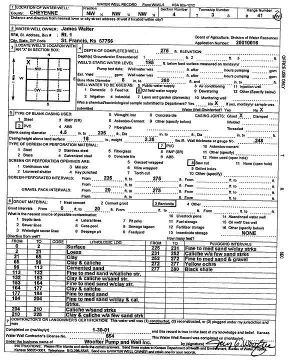
Specific Water Well Detail |
|
|
| Location Info | |||
| Owner: Walter, James | Status: Constructed | ||
| Location: T3S, R41W, Sec. 4, NW NW NW | County: Cheyenne | ||
| Directions: | |||
| Latitude: 39.8280823 | Longitude: -101.9352608 | Datum NAD 27 | |
| Latitude: 39.8280747 | Longitude: -101.9357194 | Datum NAD 83 | |
| Longitude and latitude calculated by Survey from township-range-section-quarter calls. Only good to within the quarter call accuracy. | |||
| View well on interactive map | |||
| General Info | ||
| Well Depth: 275 ft. | Elevation: ft. | |
| Static Water Level: 195 ft. | Est. Yield: gpm. | |
| Comp. Date: 30-Jan-2001 | Well Use: Oil Field Water Supply | |
| DWR Applic. #: 20010016 | Other ID: | |
| Links | |
| No Wizard information available. | |
| View info from WIMAS Water Right Data base... | |
| Driller Info | ||
| Driller: Jay C. Woofter Pump & Well, Inc. | License #: 554 | |
| Scanned Form | View scan |
|
Chemical Sample Submitted?:
Water Well disinfected?: | ||
| Casing Info | ||
| Casing Type:
Casing Joints: |
Diam: in. to ft | |
| Casing height above land surface: in
Casing Weight: lbs/ft Wall thickness or gauge no.: | ||
| Screen and Perforation Info | ||
| Screen Type: | Screen Openings: | |
| Screen-perforated intervals | From: ft to ft | |
| Gravel pack intervals | From: ft to ft | |
| Grout Info | ||
| Grout used: | From: to ft | |
| Source of Possible Contamination | ||
| Source: | ||
| Direction from well: | Distance: ft | |
| Lithologic Log
(Log data entered by KGS.) | ||
| From: 0 ft. to 2 ft. | Surface | |
| From: 2 ft. to 21 ft. | Loess | |
| From: 21 ft. to 65 ft. | Clay | |
| From: 65 ft. to 98 ft. | Clay and caliche | |
| From: 98 ft. to 113 ft. | Cemented sand | |
| From: 113 ft. to 132 ft. | Fine to medium sand with caliche streak | |
| From: 132 ft. to 153 ft. | Clay and caliche with sand streak | |
| From: 153 ft. to 164 ft. | Fine to medium sand with clay streak | |
| From: 164 ft. to 177 ft. | Clay and caliche | |
| From: 177 ft. to 184 ft. | Fine to medium sand | |
| From: 184 ft. to 204 ft. | Fine to medium sand with clay and caliche streaks | |
| From: 204 ft. to 210 ft. | Caliche with sand streaks | |
| From: 210 ft. to 225 ft. | Clay and caliche with a few sand streaks | |
| From: 225 ft. to 231 ft. | Fine to medium sand with clay streaks | |
| From: 231 ft. to 252 ft. | Caliche with a few sand streaks | |
| From: 252 ft. to 272 ft. | Fine to medium sand and gravel | |
| From: 272 ft. to 277 ft. | Yellow ochre | |
| From: 277 ft. to 280 ft. | Black shale | |