|
|
|
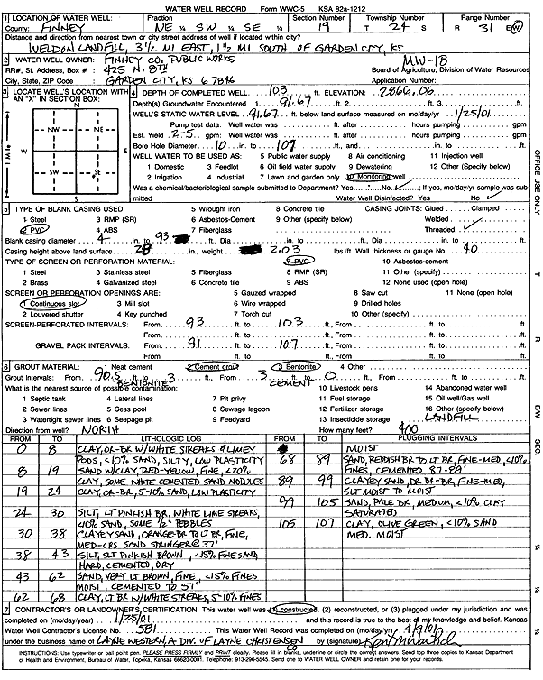
Specific Water Well Detail |
|
|
| Location Info | |||
| Owner: Finney County Public Works | Status: Constructed | ||
| Location: T24S, R31W, Sec. 19, NE SW SE | County: Finney | ||
| Directions: Weldon Landfill - 3.5 mi E, 1.5 mi S of Garden City | |||
| Latitude: 37.9483052 | Longitude: -100.7613482 | Datum NAD 27 | |
| Latitude: 37.9483275 | Longitude: -100.7617836 | Datum NAD 83 | |
| Longitude and latitude calculated by Survey from township-range-section-quarter calls. Only good to within the quarter call accuracy. | |||
| View well on interactive map | |||
| General Info | ||
| Well Depth: 103 ft. | Elevation: 2866.06 ft. | |
| Static Water Level: 91.67 ft. | Est. Yield: gpm. | |
| Comp. Date: 25-Jan-2001 | Well Use: Monitoring well/observation/piezometer | |
| DWR Applic. #: | Other ID: MW 18 | |
| Driller Info | ||
| Driller: Layne Western | License #: 581 | |
| Scanned Form | View scan |
|
Chemical Sample Submitted?:
Water Well disinfected?: | ||
| Casing Info | ||
| Casing Type:
Casing Joints: |
Diam: in. to ft | |
| Casing height above land surface: in
Casing Weight: lbs/ft Wall thickness or gauge no.: | ||
| Screen and Perforation Info | ||
| Screen Type: | Screen Openings: | |
| Screen-perforated intervals | From: ft to ft | |
| Gravel pack intervals | From: ft to ft | |
| Grout Info | ||
| Grout used: | From: to ft | |
| Source of Possible Contamination | ||
| Source: | ||
| Direction from well: | Distance: ft | |
| Lithologic Log
(Log data entered by KGS.) | ||
| From: 0 ft. to 8 ft. | clay, orange-brown with white streaks and limey pods, less than 10% sand, silty, low plasticity | |
| From: 8 ft. to 19 ft. | sand with clay, red-yellow, fine, less than 20% clay, some white cemented sand nodules | |
| From: 19 ft. to 24 ft. | clay, orange-brown, 5-10% sand, low plasticity | |
| From: 24 ft. to 30 ft. | silt, lt pinkish brown, white lime streaks, less than 10% sand, some 1/2 inch pebbles | |
| From: 30 ft. to 38 ft. | clayey sand, orange-brown to light brown fine, medium-coarse sand, stringer at 37 feet | |
| From: 38 ft. to 43 ft. | silt, slight pinkish brown, less than 15% fine sand, hard, cemented, dry | |
| From: 43 ft. to 62 ft. | sand, very light brown, fine, less than 15% fines moist, cemented to 51 feet | |
| From: 62 ft. to 68 ft. | clay, light brown with white streaks, 5-10% fines moist | |
| From: 68 ft. to 89 ft. | sand, reddish brown to light brown, fine-med, less than 10% fines, cemented 87-89 feet | |
| From: 89 ft. to 99 ft. | clayey sand, dark brown-brown, fine-med, slightly moist to moist | |
| From: 99 ft. to 105 ft. | sand, pale brown, medium, less than 10% clay saturated | |
| From: 105 ft. to 107 ft. | clay, olive green, less than 10% sand med. Moist | |