|
|
|
Specific Water Well Detail |
|
|
| Location Info | |||
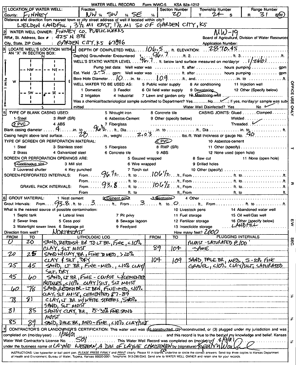
| Owner: Finney County Public Works | Status: Constructed | ||
| Location: T24S, R31W, Sec. 20, NW SW SE | County: Finney | ||
| Directions: Weldon Landfill - 3.5 mi E, 1.5 mi S of Garden City | |||
| Latitude: 37.9480557 | Longitude: -100.745316 | Datum NAD 27 | |
| Latitude: 37.9480779 | Longitude: -100.7457508 | Datum NAD 83 | |
| Longitude and latitude calculated by Survey from township-range-section-quarter calls. Only good to within the quarter call accuracy. | |||
| View well on interactive map | |||
| General Info | ||
| Well Depth: 106.5 ft. | Elevation: 2870.45 ft. | |
| Static Water Level: 96.7 ft. | Est. Yield: gpm. | |
| Comp. Date: 26-Jan-2001 | Well Use: Monitoring well/observation/piezometer | |
| DWR Applic. #: | Other ID: MW 19 | |
| Driller Info | ||
| Driller: Layne Western | License #: 581 | |
| Scanned Form | View scan |
|
Chemical Sample Submitted?:
Water Well disinfected?: | ||
| Casing Info | ||
| Casing Type:
Casing Joints: |
Diam: in. to ft | |
| Casing height above land surface: in
Casing Weight: lbs/ft Wall thickness or gauge no.: | ||
| Screen and Perforation Info | ||
| Screen Type: | Screen Openings: | |
| Screen-perforated intervals | From: ft to ft | |
| Gravel pack intervals | From: ft to ft | |
| Grout Info | ||
| Grout used: | From: to ft | |
| Source of Possible Contamination | ||
| Source: | ||
| Direction from well: | Distance: ft | |
| Lithologic Log
(Log data entered by KGS.) | ||
| From: 0 ft. to 20 ft. | sand, reddish brown to light brown, fine, less than 10% clay, slightly moist | |
| From: 20 ft. to 25 ft. | sand with clay, brown, fine to med, more than 20% clay and silt, dry | |
| From: 25 ft. to 45 ft. | sand, light brown, fine-med, less than 10% clay/silt, dry | |
| From: 45 ft. to 60 ft. | fine-coarse sand, light brown, with cemented nodules, less than 10% clay/silt, slightly moist | |
| From: 60 ft. to 78 ft. | sand, reddish brown-light brown, fine-med, less than 10% clay, slightly moist, cemented 87-89 feet | |
| From: 78 ft. to 81 ft. | clay, slightly brown with white streaks, 5-10% sand, slightly moist | |
| From: 81 ft. to 85 ft. | sandy clay, brown, 15-30% fine sand moist | |
| From: 85 ft. to 89 ft. | sand, pale brown, med-fine, less than 10% clay/silt moist - saturated at 100 feet | |
| From: 89 ft. to 104 ft. | sand, pale brown, med-fine, less than 10% clay/silt moist - saturated at 100 feet | |
| From: 104 ft. to 109 ft. | sand, pale brown, medium, 5-10% fine gravel, less than 10% clay/silt, saturated | |