|
|
|
Specific Water Well Detail |
|
|
| Location Info | |||
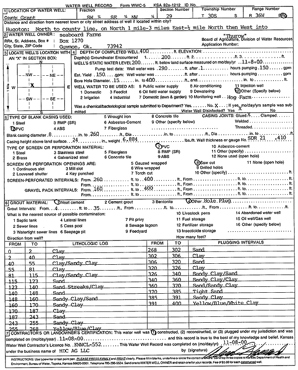
| Owner: Seaboard Farms | Status: Constructed | ||
| Location: T30S, R36W, Sec. 29, SW SE NW | County: Grant | ||
| Directions: from Hugoton: N to Co. line, 1 mi. N, 3 mi E, .25 mi N, W into site | |||
| Latitude: 37.4105889 | Longitude: -101.2831966 | Datum NAD 27 | |
| Latitude: 37.4106123 | Longitude: -101.2836388 | Datum NAD 83 | |
| Longitude and latitude calculated by Survey from township-range-section-quarter calls. Only good to within the quarter call accuracy. | |||
| View well on interactive map | |||
| General Info | ||
| Well Depth: 400 ft. | Elevation: ft. | |
| Static Water Level: 200 ft. | Est. Yield: gpm. | |
| Comp. Date: 08-Nov-2000 | Well Use: Feedlot | |
| DWR Applic. #: | Other ID: | |
| Links | |
| No Wizard information available. | |
| View info from WIMAS Water Right Data base... | |
| Driller Info | ||
| Driller: H.D.C. AG, LLC | License #: 652 | |
| Scanned Form | View scan |
|
Chemical Sample Submitted?:
Water Well disinfected?: | ||
| Casing Info | ||
| Casing Type:
Casing Joints: |
Diam: in. to ft | |
| Casing height above land surface: in
Casing Weight: lbs/ft Wall thickness or gauge no.: | ||
| Screen and Perforation Info | ||
| Screen Type: | Screen Openings: | |
| Screen-perforated intervals | From: ft to ft | |
| Gravel pack intervals | From: ft to ft | |
| Grout Info | ||
| Grout used: | From: to ft | |
| Source of Possible Contamination | ||
| Source: | ||
| Direction from well: | Distance: ft | |
| Lithologic Log
(Log data entered by KGS.) | ||
| From: 0 ft. to 2 ft. | Clay | |
| From: 2 ft. to 40 ft. | Clay | |
| From: 40 ft. to 55 ft. | Clay/Sandy Clay | |
| From: 55 ft. to 81 ft. | Clay | |
| From: 81 ft. to 115 ft. | Clay/Sandy Clay | |
| From: 115 ft. to 123 ft. | Sand | |
| From: 123 ft. to 140 ft. | Sand Streaks/Clay | |
| From: 140 ft. to 148 ft. | Sand | |
| From: 148 ft. to 160 ft. | Sandy Clay/Sand | |
| From: 160 ft. to 170 ft. | Sandy Clay | |
| From: 170 ft. to 187 ft. | Clay | |
| From: 187 ft. to 243 ft. | Sand | |
| From: 243 ft. to 255 ft. | Sandy Clay | |
| From: 255 ft. to 268 ft. | Yellow/Blue/Clay | |
| From: 268 ft. to 302 ft. | Sand | |
| From: 302 ft. to 306 ft. | Clay | |
| From: 306 ft. to 320 ft. | Sand | |
| From: 320 ft. to 326 ft. | Clay | |
| From: 326 ft. to 340 ft. | Sandy Clay/Sand | |
| From: 340 ft. to 360 ft. | Sandy Clay/Clay | |
| From: 360 ft. to 370 ft. | Sand/Sandy Clay | |
| From: 370 ft. to 385 ft. | Tight Sand | |
| From: 385 ft. to 391 ft. | Sandy Clay | |
| From: 391 ft. to 400 ft. | Yellow/Blue/White Clay | |