|
|
|
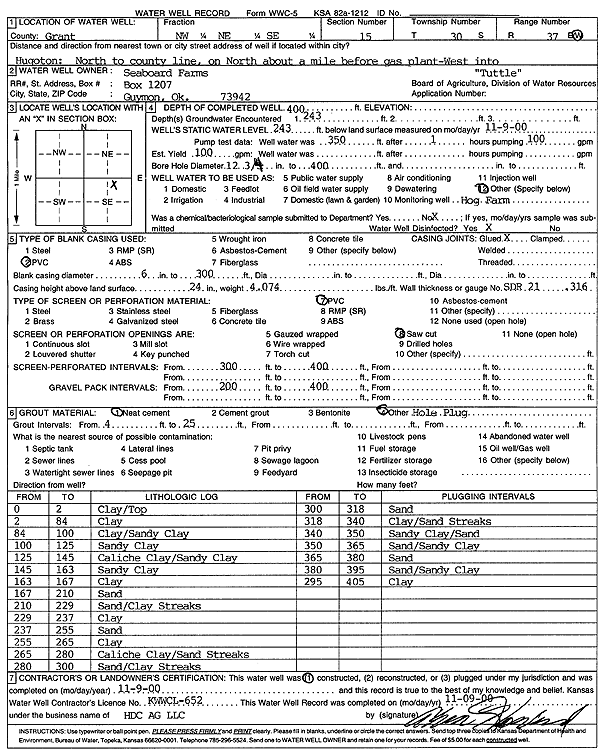
Specific Water Well Detail |
|
|
| Location Info | |||
| Owner: Seaboard Farms Co. | Status: Constructed | ||
| Location: T30S, R37W, Sec. 15, NW NE SE | County: Grant | ||
| Directions: from Hugoton: N to Co. line, N 1 mi (before gas plant), W into site | |||
| Latitude: 37.4377881 | Longitude: -101.3469027 | Datum NAD 27 | |
| Latitude: 37.4378108 | Longitude: -101.3473462 | Datum NAD 83 | |
| Longitude and latitude calculated by Survey from township-range-section-quarter calls. Only good to within the quarter call accuracy. | |||
| View well on interactive map | |||
| General Info | ||
| Well Depth: 400 ft. | Elevation: ft. | |
| Static Water Level: 243 ft. | Est. Yield: gpm. | |
| Comp. Date: 09-Nov-2000 | Well Use: Feedlot | |
| DWR Applic. #: | Other ID: Tuttle | |
| Driller Info | ||
| Driller: H.D.C. AG, LLC | License #: 652 | |
| Scanned Form | View scan |
|
Chemical Sample Submitted?:
Water Well disinfected?: | ||
| Casing Info | ||
| Casing Type:
Casing Joints: |
Diam: in. to ft | |
| Casing height above land surface: in
Casing Weight: lbs/ft Wall thickness or gauge no.: | ||
| Screen and Perforation Info | ||
| Screen Type: | Screen Openings: | |
| Screen-perforated intervals | From: ft to ft | |
| Gravel pack intervals | From: ft to ft | |
| Grout Info | ||
| Grout used: | From: to ft | |
| Source of Possible Contamination | ||
| Source: | ||
| Direction from well: | Distance: ft | |
| Lithologic Log
(Log data entered by KGS.) | ||
| From: 0 ft. to 2 ft. | Clay/Top | |
| From: 2 ft. to 84 ft. | Clay | |
| From: 84 ft. to 100 ft. | Clay/Sandy Clay | |
| From: 100 ft. to 125 ft. | Sandy Clay | |
| From: 125 ft. to 145 ft. | Caliche Clay/Sandy Clay | |
| From: 145 ft. to 163 ft. | Sandy Clay | |
| From: 163 ft. to 167 ft. | Clay | |
| From: 167 ft. to 210 ft. | Sand | |
| From: 210 ft. to 229 ft. | Sand/Clay Streaks | |
| From: 229 ft. to 237 ft. | Clay | |
| From: 237 ft. to 255 ft. | Sand | |
| From: 255 ft. to 265 ft. | Clay | |
| From: 265 ft. to 280 ft. | Caliche Clay/Sand Streaks | |
| From: 280 ft. to 300 ft. | Sand/Clay Streaks | |
| From: 300 ft. to 318 ft. | Sand | |
| From: 318 ft. to 340 ft. | Clay/Sand Streaks | |
| From: 340 ft. to 350 ft. | Sandy Clay/Sand | |
| From: 350 ft. to 365 ft. | Sand/Sandy Clay | |
| From: 365 ft. to 380 ft. | Sand | |
| From: 380 ft. to 395 ft. | Sand/Sandy Clay | |
| From: 395 ft. to 405 ft. | Clay | |