|
|
|
Specific Water Well Detail |
|
|
| Location Info | |||
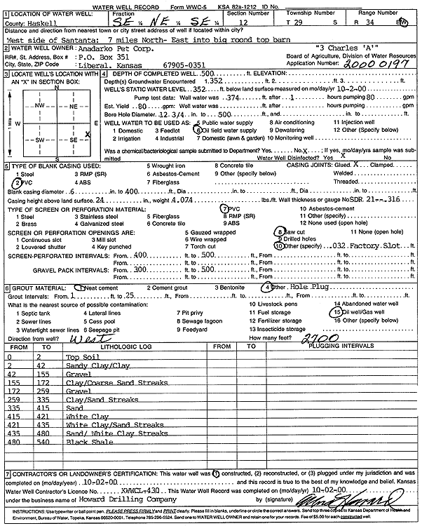
| Owner: Anadarko Petroleum Corp. | Status: Constructed | ||
| Location: T29S, R34W, Sec. 12, SE NE SE | County: Haskell | ||
| Directions: from W side of Satanta: 7 mi N, E into big round top barn | |||
| Latitude: 37.5376713 | Longitude: -100.9814624 | Datum NAD 27 | |
| Latitude: 37.5376959 | Longitude: -100.9819078 | Datum NAD 83 | |
| Longitude and latitude calculated by Survey from township-range-section-quarter calls. Only good to within the quarter call accuracy. | |||
| View well on interactive map | |||
| General Info | ||
| Well Depth: 500 ft. | Elevation: ft. | |
| Static Water Level: 352 ft. | Est. Yield: gpm. | |
| Comp. Date: 02-Oct-2000 | Well Use: Oil Field Water Supply | |
| DWR Applic. #: 20000197 | Other ID: | |
| Links | |
| No Wizard information available. | |
| View info from WIMAS Water Right Data base... | |
| Driller Info | ||
| Driller: Howard Drilling Company AG, LLC | License #: 430 | |
| Scanned Form | View scan |
|
Chemical Sample Submitted?:
Water Well disinfected?: | ||
| Casing Info | ||
| Casing Type:
Casing Joints: |
Diam: in. to ft | |
| Casing height above land surface: in
Casing Weight: lbs/ft Wall thickness or gauge no.: | ||
| Screen and Perforation Info | ||
| Screen Type: | Screen Openings: | |
| Screen-perforated intervals | From: ft to ft | |
| Gravel pack intervals | From: ft to ft | |
| Grout Info | ||
| Grout used: | From: to ft | |
| Source of Possible Contamination | ||
| Source: | ||
| Direction from well: | Distance: ft | |
| Lithologic Log
(Log data entered by KGS.) | ||
| From: 0 ft. to 2 ft. | top soil | |
| From: 2 ft. to 42 ft. | sandy clay/clay | |
| From: 42 ft. to 155 ft. | gravel | |
| From: 155 ft. to 172 ft. | clay/coarse sand streaks | |
| From: 172 ft. to 259 ft. | gravel | |
| From: 259 ft. to 335 ft. | clay/sand streaks | |
| From: 335 ft. to 415 ft. | sand | |
| From: 415 ft. to 421 ft. | white clay | |
| From: 421 ft. to 435 ft. | white clay/sand streaks | |
| From: 435 ft. to 480 ft. | sand/white clay streaks | |
| From: 480 ft. to 540 ft. | black shale | |