|
|
|
Specific Water Well Detail |
|
|
| Location Info | |||
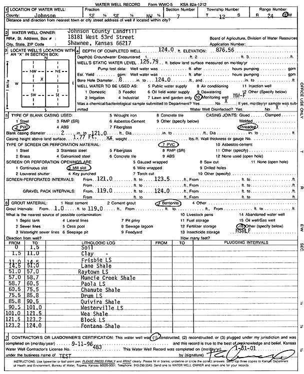
| Owner: Johnson County Landfill | Status: Constructed | ||
| Location: T12S, R24E, Sec. 7, SE SE NW | County: Johnson | ||
| Directions: | |||
| Latitude: 39.0228999 | Longitude: -94.7895919 | Datum NAD 27 | |
| Latitude: 39.022905 | Longitude: -94.7898315 | Datum NAD 83 | |
| Longitude and latitude calculated by Survey from township-range-section-quarter calls. Only good to within the quarter call accuracy. | |||
| View well on interactive map | |||
| General Info | ||
| Well Depth: 124 ft. | Elevation: 876.56 ft. | |
| Static Water Level: 125.8 ft. | Est. Yield: gpm. | |
| Comp. Date: 11-Sep-1996 | Well Use: Monitoring well/observation/piezometer | |
| DWR Applic. #: | Other ID: MW F | |
| Driller Info | ||
| Driller: Defenbaugh Industries, Inc. (T.E.S.T.) | License #: 483 | |
| Scanned Form | View scan |
|
Chemical Sample Submitted?:
Water Well disinfected?: | ||
| Casing Info | ||
| Casing Type:
Casing Joints: |
Diam: in. to ft | |
| Casing height above land surface: in
Casing Weight: lbs/ft Wall thickness or gauge no.: | ||
| Screen and Perforation Info | ||
| Screen Type: | Screen Openings: | |
| Screen-perforated intervals | From: ft to ft | |
| Gravel pack intervals | From: ft to ft | |
| Grout Info | ||
| Grout used: | From: to ft | |
| Source of Possible Contamination | ||
| Source: | ||
| Direction from well: | Distance: ft | |
| Lithologic Log
(Log data entered by KGS.) | ||
| From: 0 ft. to 1.5 ft. | soil | |
| From: 1.5 ft. to 11 ft. | clay | |
| From: 11 ft. to 14.5 ft. | Frisbie Limestone | |
| From: 14.5 ft. to 51 ft. | Lane Shale | |
| From: 51 ft. to 57 ft. | Raytown Limestone | |
| From: 57 ft. to 58.7 ft. | Muncie Creek Shale | |
| From: 58.7 ft. to 60.5 ft. | Paola Limestone | |
| From: 60.5 ft. to 75.5 ft. | Chanute Shale | |
| From: 75.5 ft. to 85.8 ft. | Drum Limestone | |
| From: 85.8 ft. to 90.5 ft. | Quivira Shale | |
| From: 90.5 ft. to 101 ft. | Westerville Limestone | |
| From: 101 ft. to 121.5 ft. | Wea Shale | |
| From: 121.5 ft. to 123.2 ft. | Block Limestone | |
| From: 123.2 ft. to 124 ft. | Fontana Shale | |