|
|
|
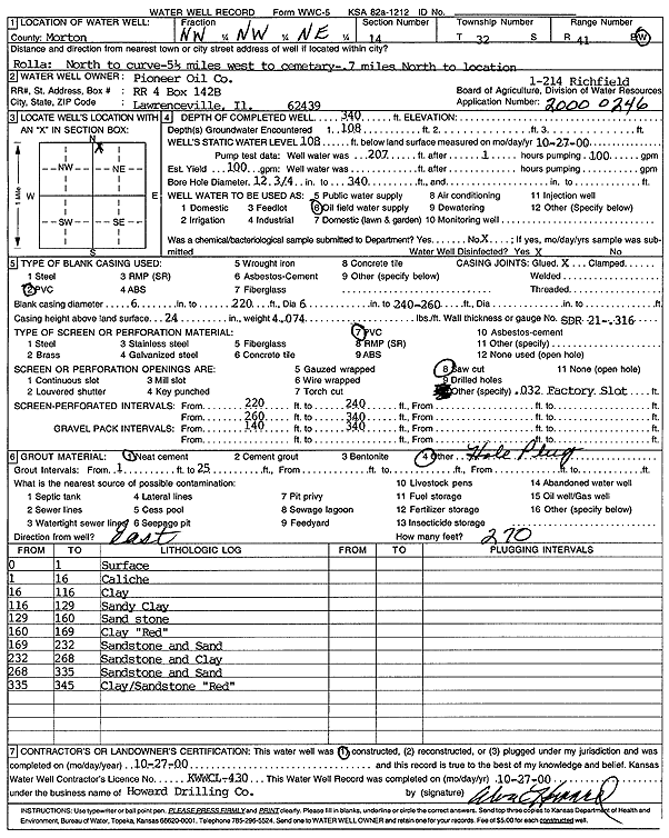
Specific Water Well Detail |
|
|
| Location Info | |||
| Owner: Pioneer Oil Co. | Status: Constructed | ||
| Location: T32S, R41W, Sec. 14, NW NW NE | County: Morton | ||
| Directions: from Rolla: N to curve, 5.5 mi W to cemetary, .7 mi N to location | |||
| Latitude: 37.271662 | Longitude: -101.74463 | Datum NAD 27 | |
| Latitude: 37.2716852 | Longitude: -101.7450734 | Datum NAD 83 | |
| Longitude and latitude calculated by Survey from township-range-section-quarter calls. Only good to within the quarter call accuracy. | |||
| View well on interactive map | |||
| General Info | ||
| Well Depth: 340 ft. | Elevation: ft. | |
| Static Water Level: 108 ft. | Est. Yield: 100 gpm. | |
| Comp. Date: 27-Oct-2000 | Well Use: Oil Field Water Supply | |
| DWR Applic. #: 20000246 | Other ID: Richfield 1-214 | |
| Links | |
| No Wizard information available. | |
| View info from WIMAS Water Right Data base... | |
| Driller Info | ||
| Driller: Howard Drilling Company AG, LLC | License #: 430 | |
| Scanned Form | View scan |
|
Chemical Sample Submitted?:
Water Well disinfected?: | ||
| Casing Info | ||
| Casing Type:
Casing Joints: |
Diam: in. to ft | |
| Casing height above land surface: in
Casing Weight: lbs/ft Wall thickness or gauge no.: | ||
| Screen and Perforation Info | ||
| Screen Type: | Screen Openings: | |
| Screen-perforated intervals | From: ft to ft | |
| Gravel pack intervals | From: ft to ft | |
| Grout Info | ||
| Grout used: | From: to ft | |
| Source of Possible Contamination | ||
| Source: | ||
| Direction from well: | Distance: ft | |
| Lithologic Log
(Log data entered by KGS.) | ||
| From: 0 ft. to 1 ft. | surface | |
| From: 1 ft. to 16 ft. | caliche | |
| From: 16 ft. to 116 ft. | clay | |
| From: 116 ft. to 129 ft. | sandy clay | |
| From: 129 ft. to 160 ft. | sandstone | |
| From: 160 ft. to 169 ft. | clay, red | |
| From: 169 ft. to 232 ft. | sandstone and sand | |
| From: 232 ft. to 268 ft. | sandstone and clay | |
| From: 268 ft. to 335 ft. | sandstone and sand | |
| From: 335 ft. to 345 ft. | clay/sandstone, red | |