|
|
|
Specific Water Well Detail |
|
|
| Location Info | |||
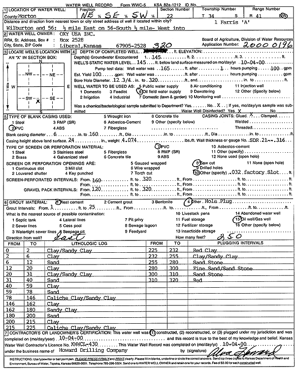
| Owner: Oxy USA, Inc. | Status: Constructed | ||
| Location: T34S, R41W, Sec. 22, NE SE SW | County: Morton | ||
| Directions: from Wilburton and 56: .5 E on 56, .5 mi S, W into site | |||
| Latitude: 37.07172 | Longitude: -101.7644745 | Datum NAD 27 | |
| Latitude: 37.0717446 | Longitude: -101.7649154 | Datum NAD 83 | |
| Longitude and latitude calculated by Survey from township-range-section-quarter calls. Only good to within the quarter call accuracy. | |||
| View well on interactive map | |||
| General Info | ||
| Well Depth: 320 ft. | Elevation: ft. | |
| Static Water Level: 145 ft. | Est. Yield: 100 gpm. | |
| Comp. Date: 04-Oct-2000 | Well Use: Oil Field Water Supply | |
| DWR Applic. #: 20000196 | Other ID: Farris A 1 | |
| Links | |
| No Wizard information available. | |
| View info from WIMAS Water Right Data base... | |
| Driller Info | ||
| Driller: Howard Drilling Company AG, LLC | License #: 430 | |
| Scanned Form | View scan |
|
Chemical Sample Submitted?:
Water Well disinfected?: | ||
| Casing Info | ||
| Casing Type:
Casing Joints: |
Diam: in. to ft | |
| Casing height above land surface: in
Casing Weight: lbs/ft Wall thickness or gauge no.: | ||
| Screen and Perforation Info | ||
| Screen Type: | Screen Openings: | |
| Screen-perforated intervals | From: ft to ft | |
| Gravel pack intervals | From: ft to ft | |
| Grout Info | ||
| Grout used: | From: to ft | |
| Source of Possible Contamination | ||
| Source: | ||
| Direction from well: | Distance: ft | |
| Lithologic Log
(Log data entered by KGS.) | ||
| From: 0 ft. to 2 ft. | clay/sandy clay | |
| From: 2 ft. to 6 ft. | clay | |
| From: 6 ft. to 12 ft. | sand | |
| From: 12 ft. to 20 ft. | clay | |
| From: 20 ft. to 31 ft. | clay/sandy clay | |
| From: 31 ft. to 40 ft. | sand | |
| From: 40 ft. to 59 ft. | clay | |
| From: 59 ft. to 78 ft. | sand | |
| From: 78 ft. to 146 ft. | caliche clay/sandy clay | |
| From: 146 ft. to 162 ft. | clay | |
| From: 162 ft. to 180 ft. | sandy clay | |
| From: 180 ft. to 200 ft. | sand | |
| From: 200 ft. to 215 ft. | clay | |
| From: 215 ft. to 225 ft. | caliche clay/sandy clay | |
| From: 225 ft. to 232 ft. | red clay | |
| From: 232 ft. to 255 ft. | clay/sandy clay | |
| From: 255 ft. to 280 ft. | sandstone | |
| From: 280 ft. to 300 ft. | fine sand/sandstone | |
| From: 300 ft. to 310 ft. | sandstone | |
| From: 310 ft. to 320 ft. | red | |