|
|
|
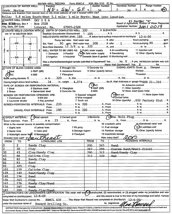
Specific Water Well Detail |
|
|
| Location Info | |||
| Owner: Oxy USA, Inc. | Status: Constructed | ||
| Location: T34S, R41W, Sec. 36, NE SW SE | County: Morton | ||
| Directions: from Rolla: 5.8 mi S, 5.1 mi W, .25 mi N, W into location | |||
| Latitude: 37.0426645 | Longitude: -101.7235298 | Datum NAD 27 | |
| Latitude: 37.0426897 | Longitude: -101.7239695 | Datum NAD 83 | |
| Longitude and latitude calculated by Survey from township-range-section-quarter calls. Only good to within the quarter call accuracy. | |||
| View well on interactive map | |||
| General Info | ||
| Well Depth: 320 ft. | Elevation: ft. | |
| Static Water Level: 185 ft. | Est. Yield: 90 gpm. | |
| Comp. Date: 06-Dec-2000 | Well Use: Oil Field Water Supply | |
| DWR Applic. #: 20010019 | Other ID: Barber B 3 | |
| Links | |
| No Wizard information available. | |
| View info from WIMAS Water Right Data base... | |
| Driller Info | ||
| Driller: Howard Drilling Company AG, LLC | License #: 430 | |
| Scanned Form | View scan |
|
Chemical Sample Submitted?:
Water Well disinfected?: | ||
| Casing Info | ||
| Casing Type:
Casing Joints: |
Diam: in. to ft | |
| Casing height above land surface: in
Casing Weight: lbs/ft Wall thickness or gauge no.: | ||
| Screen and Perforation Info | ||
| Screen Type: | Screen Openings: | |
| Screen-perforated intervals | From: ft to ft | |
| Gravel pack intervals | From: ft to ft | |
| Grout Info | ||
| Grout used: | From: to ft | |
| Source of Possible Contamination | ||
| Source: | ||
| Direction from well: | Distance: ft | |
| Lithologic Log
(Log data entered by KGS.) | ||
| From: 0 ft. to 2 ft. | sandy clay | |
| From: 2 ft. to 30 ft. | clay | |
| From: 30 ft. to 45 ft. | clay/sandy clay | |
| From: 45 ft. to 66 ft. | caliche clay | |
| From: 66 ft. to 82 ft. | sandy clay | |
| From: 82 ft. to 93 ft. | sand | |
| From: 93 ft. to 105 ft. | clay | |
| From: 105 ft. to 129 ft. | caliche clay | |
| From: 129 ft. to 140 ft. | sand/sandy clay | |
| From: 140 ft. to 156 ft. | sand | |
| From: 156 ft. to 163 ft. | clay | |
| From: 163 ft. to 176 ft. | sandy clay/sand | |
| From: 176 ft. to 187 ft. | sand | |
| From: 187 ft. to 200 ft. | sandy clay/sand | |
| From: 200 ft. to 267 ft. | sand | |
| From: 267 ft. to 290 ft. | coarse sand/small gravel | |
| From: 290 ft. to 312 ft. | sand/sandy clay | |
| From: 312 ft. to 320 ft. | red | |