|
|
|
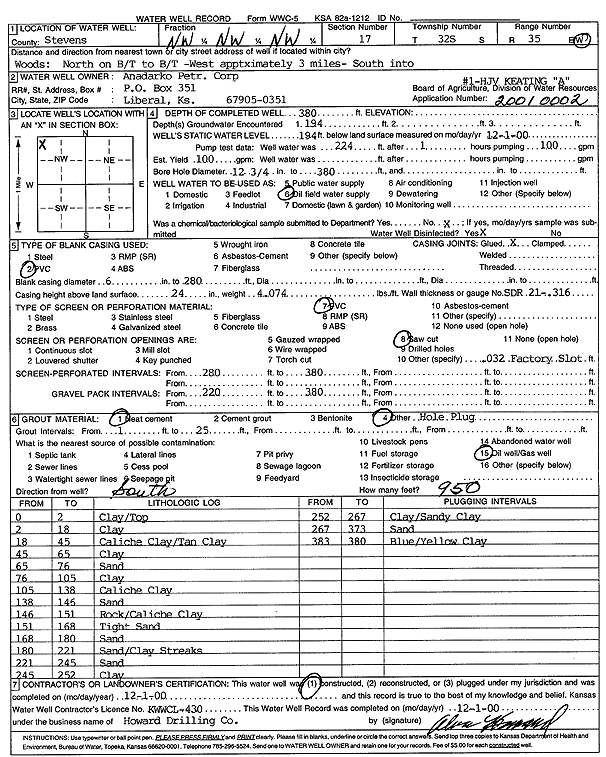
Specific Water Well Detail |
|
|
| Location Info | |||
| Owner: Anadarko Petroleum Corp. | Status: Constructed | ||
| Location: T32S, R35W, Sec. 17, NW NW NW | County: Stevens | ||
| Directions: from Woods: N on blacktop, to blacktop - 3 mi W, S into site | |||
| Latitude: 37.2704432 | Longitude: -101.1567706 | Datum NAD 27 | |
| Latitude: 37.2704672 | Longitude: -101.1572084 | Datum NAD 83 | |
| Longitude and latitude calculated by Survey from township-range-section-quarter calls. Only good to within the quarter call accuracy. | |||
| View well on interactive map | |||
| General Info | ||
| Well Depth: 380 ft. | Elevation: ft. | |
| Static Water Level: 194 ft. | Est. Yield: 100 gpm. | |
| Comp. Date: 01-Dec-2000 | Well Use: Oil Field Water Supply | |
| DWR Applic. #: 20010002 | Other ID: HJV Keating A-1 | |
| Links | |
| No Wizard information available. | |
| View info from WIMAS Water Right Data base... | |
| Driller Info | ||
| Driller: Howard Drilling Company AG, LLC | License #: 430 | |
| Scanned Form | View scan |
|
Chemical Sample Submitted?:
Water Well disinfected?: | ||
| Casing Info | ||
| Casing Type:
Casing Joints: |
Diam: in. to ft | |
| Casing height above land surface: in
Casing Weight: lbs/ft Wall thickness or gauge no.: | ||
| Screen and Perforation Info | ||
| Screen Type: | Screen Openings: | |
| Screen-perforated intervals | From: ft to ft | |
| Gravel pack intervals | From: ft to ft | |
| Grout Info | ||
| Grout used: | From: to ft | |
| Source of Possible Contamination | ||
| Source: | ||
| Direction from well: | Distance: ft | |
| Lithologic Log
(Log data entered by KGS.) | ||
| From: 0 ft. to 2 ft. | clay/top | |
| From: 2 ft. to 18 ft. | clay | |
| From: 18 ft. to 45 ft. | caliche clay/tan clay | |
| From: 45 ft. to 65 ft. | clay | |
| From: 65 ft. to 76 ft. | sand | |
| From: 76 ft. to 105 ft. | clay | |
| From: 105 ft. to 138 ft. | caliche clay | |
| From: 138 ft. to 145 ft. | sand | |
| From: 145 ft. to 151 ft. | rock/caliche clay | |
| From: 151 ft. to 168 ft. | tight sand | |
| From: 168 ft. to 180 ft. | sand | |
| From: 180 ft. to 221 ft. | sand/clay streaks | |
| From: 221 ft. to 245 ft. | sand | |
| From: 245 ft. to 252 ft. | clay | |
| From: 252 ft. to 267 ft. | clay/sandy clay | |
| From: 267 ft. to 373 ft. | sand | |
| From: 373 ft. to 380 ft. | blue/yellow clay | |