|
|
|
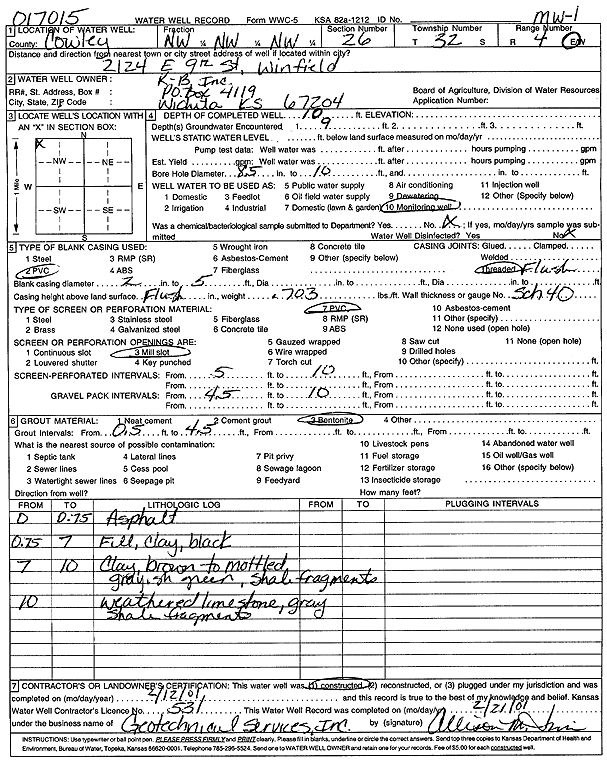
Specific Water Well Detail |
|
|
| Location Info | |||
| Owner: K-B Inc. | Status: Constructed | ||
| Location: T32S, R4E, Sec. 26, NW NW NW | County: Cowley | ||
| Directions: 2124 E 9th St, Winfield | |||
| Latitude: 37.2439231 | Longitude: -96.968091 | Datum NAD 27 | |
| Latitude: 37.2439495 | Longitude: -96.9684045 | Datum NAD 83 | |
| Longitude and latitude calculated by Survey from township-range-section-quarter calls. Only good to within the quarter call accuracy. | |||
| View well on interactive map | |||
| General Info | ||
| Well Depth: 10 ft. | Elevation: ft. | |
| Static Water Level: ft. | Est. Yield: gpm. | |
| Comp. Date: 12-Feb-2001 | Well Use: Monitoring well/observation/piezometer | |
| DWR Applic. #: 017015 | Other ID: MW 1 | |
| Driller Info | ||
| Driller: Geotechnical Services, Inc. | License #: 531 | |
| Scanned Form | View scan |
|
Chemical Sample Submitted?:
Water Well disinfected?: | ||
| Casing Info | ||
| Casing Type:
Casing Joints: |
Diam: in. to ft | |
| Casing height above land surface: in
Casing Weight: lbs/ft Wall thickness or gauge no.: | ||
| Screen and Perforation Info | ||
| Screen Type: | Screen Openings: | |
| Screen-perforated intervals | From: ft to ft | |
| Gravel pack intervals | From: ft to ft | |
| Grout Info | ||
| Grout used: | From: to ft | |
| Source of Possible Contamination | ||
| Source: | ||
| Direction from well: | Distance: ft | |
| Lithologic Log
(Log data entered by KGS.) | ||
| From: 0 ft. to .8 ft. | asphalt | |
| From: .8 ft. to 7 ft. | fill, clay, black | |
| From: 7 ft. to 10 ft. | clay, brown to mottled gray, shale green, shale fragments | |
| From: 10 ft. to ft. | weathered limestone, gray, shale fragments | |