|
|
|
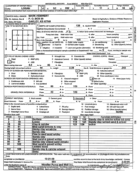
Specific Water Well Detail |
|
|
| Location Info | |||
| Owner: Hemmert, Mark | Status: Constructed | ||
| Location: T11S, R34W, Sec. 11, SE SE SW | County: Logan | ||
| Directions: | |||
| Latitude: 39.1056116 | Longitude: -101.0634655 | Datum NAD 27 | |
| Latitude: 39.1056193 | Longitude: -101.0638967 | Datum NAD 83 | |
| Longitude and latitude calculated by Survey from township-range-section-quarter calls. Only good to within the quarter call accuracy. | |||
| View well on interactive map | |||
| General Info | ||
| Well Depth: 126 ft. | Elevation: ft. | |
| Static Water Level: ft. | Est. Yield: gpm. | |
| Comp. Date: 21-Dec-2000 | Well Use: Domestic | |
| DWR Applic. #: | Other ID: | |
| Driller Info | ||
| Driller: Jay C. Woofter Pump & Well, Inc. | License #: 554 | |
| Scanned Form | View scan |
|
Chemical Sample Submitted?:
Water Well disinfected?: | ||
| Casing Info | ||
| Casing Type:
Casing Joints: |
Diam: in. to ft | |
| Casing height above land surface: in
Casing Weight: lbs/ft Wall thickness or gauge no.: | ||
| Screen and Perforation Info | ||
| Screen Type: | Screen Openings: | |
| Screen-perforated intervals | From: ft to ft | |
| Gravel pack intervals | From: ft to ft | |
| Grout Info | ||
| Grout used: | From: to ft | |
| Source of Possible Contamination | ||
| Source: | ||
| Direction from well: | Distance: ft | |
| Lithologic Log
(Log data entered by KGS.) | ||
| From: 0 ft. to 2 ft. | Surface | |
| From: 2 ft. to 18 ft. | Loess | |
| From: 18 ft. to 36 ft. | Clay and caliche | |
| From: 36 ft. to 61 ft. | Medium sand with rock and clay | |
| From: 61 ft. to 65 ft. | Sticky clay with caliche | |
| From: 65 ft. to 70 ft. | Sandy clay | |
| From: 70 ft. to 72 ft. | Fine to medium sand with clay | |
| From: 72 ft. to 74 ft. | Sandy clay | |
| From: 74 ft. to 85 ft. | Medium sand and gravel with clay | |
| From: 85 ft. to 91 ft. | Sandy clay with medium sand streaks | |
| From: 91 ft. to 102 ft. | Medium sand and gravel with clay lenses loose | |
| From: 102 ft. to 108 ft. | Sandy clay and caliche with sand streaks | |
| From: 108 ft. to 118 ft. | Sandy clay and caliche with fine sand streaks | |
| From: 118 ft. to 121 ft. | Sandy clay with medium sand and gravel | |
| From: 121 ft. to 126 ft. | Ochre | |